

Compared to the Vikings, I had it easy.
All I needed to hop through the Hebrides was a rental car and a pocket full of ferry tickets. Ferries have provided a lifeline to the remote islands near Scotland’s west coast since the early 1800s.
Today, cars are “rolled on and off” in minutes, providing tourists the freedom to explore on their own schedule. Just make sure to keep the tank “topped up.” Petrol stations are few and far between.
My port of departure was the coastal village of Ullapool (OWL ah pool), a town of picturesque white-washed cottages. The small museum in Ullapool features exhibits on crofting, digging peat, sailing, fishing, and the Highland Clearances. A poster in the hotel lobby promoted a concert—not of traditional Celtic music, but John Coltrane-style free jazz.

Before heading to the islands, I took a day to enjoy the incredible craggy mountains and rocky, boggy moorlands of Assynt on Scotland’s northwest coast. The single-track road twisted, rose, and fell. Numerous blind summits had to be approached cautiously. Frequently I pulled into “passing places” to accommodate oncoming traffic. All the while, I was mesmerized by the stony moonscape.
Every time I stepped from the car to take a photo, I was swarmed by midges—tiny but vicious no-see-ums. Once I applied the recommended repellant, they left me alone.

Each of the larger mountains in the area boasts a unique shape, making them easy to recognize at a distance. Cul Mor is the tallest at 2,785 feet. Others include Cul Beag, Stac Pollaidh, Ben More Coigach, and Suilven. Suilven looks like a giant football sitting on a tee.
I drove to the lighthouse at Stoer Head, parked and hiked a few miles along the cliffs. On the way back to Ullapool, I stopped at the ruins of Ardvreck Castle and nearby Calda House. Kenneth, the second MacKenzie of Assynt, lived in Ardvreck. He built Calda House on the other side of the loch for his wife—who found living in Ardvreck too uncomfortable. Sorry, Ken.
Day One: The ferry from Ullapool to Stornaway, the M.V. Isle of Lewis, holds two decks of cars. After I pulled up the ramp, I was instructed to wait in the car until the loaded deck was raised hydraulically. After I got out, more cars drove onto the newly revealed deck below me. The ferry can hold 123 cars!
I arrived on Lewis and Harris, which sound like two islands but are one. Gaelic is the predominant spoken language on the Outer Hebrides. All of the signs are Gaelic first and English second, if at all. The population of the outer islands is twenty-seven thousand.
Like Shetland and Orkney, the Hebrides were governed by the Vikings before power was transferred in 1266 CE to various, often warring, Scottish clan chiefs. The economy is driven by tourism, agriculture, fishing, and weaving (Harris tweed).
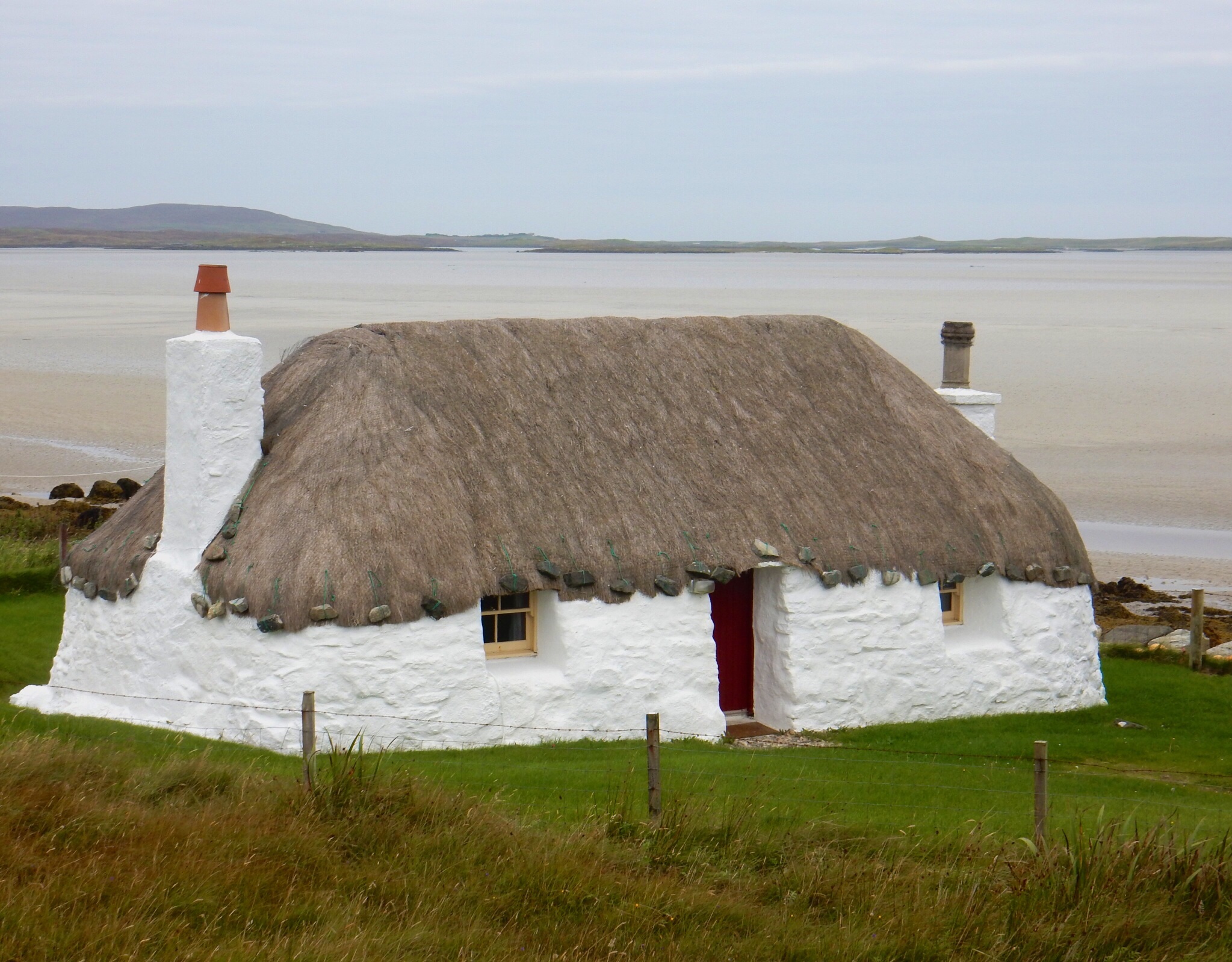
After disembarking at Stornaway, I stopped at Arnol Blackhouse, a thatched home furnished to look as it would have in the late 1800s. Inside, a peat fire was burning, the smoke rising through the thatch. The dark house had multiple living chambers, including a room at one end for the livestock. The remains of numerous abandoned blackhouses dot the coast, mixed in with more contemporary homes. Peat is still burned for fuel. The roads are lined with piles of it. I stopped to take photos of a stack of peat and talked to a local man about the process of digging, stacking, and drying. (At first, he suspected I was trying to steal some.)

I visited the Standing Stones of Calanais, a stone circle within a larger cross-shaped arrangement covering a hilltop. The fifty or so thick stone slabs were erected around 3000 BCE. I find these stone circles eerie. Calanais is quite impressive in scale and the slabs much thicker than those on Orkney.
South of the moors, as Lewis became Harris, the topography went vertical. South Harris is the scenic gem of the Hebrides. High mountain passes, broad golden beaches, crashing waves, boulder fields, rolling meadows. Spectacular views in every direction. South Harris is somewhat scary to drive as there are no guardrails on the cliff edges. And these are one-lane roads.
Numerous signs along the way pointed to the homes of local weavers of Harris tweed. An act of Parliament decrees that genuine Harris tweed must be made from pure virgin wool, dyed and spun on the islands, and handwoven in the home of an island weaver.

Day Two: The B&B owner in Leverburgh rightly insisted I see Saint Clement’s Church before boarding the ferry. The church is a fort-like chapel built by a clan chief of the Macleods in the 1500s. The chief himself is buried inside in a carved-slab warriors’ vault.
The ferry picked its way carefully among the rocky outcroppings between Leverburgh and Berneray. On North Uist, I hiked over a windy hilltop between the standing stones of Pobull Fhinn and the burial cairn Barpa Langais. The stones are positioned in a large circle, approximately one hundred feet across, overlooking a loch. About half of the forty original stones are standing. The site is not manicured and many stones are buried in the heather, a more natural presentation than the touristy sites.
A brush with royalty: In the tiny town of Lochmaddy, I just missed Princess Anne. She choppered in to dedicate the revamped harbor facility. The town was abuzz. Police everywhere. The Lochmaddy Hotel bar was full of dignitaries and pipers, celebrating the success of the event.

From the window in my room at the B&B, I watched an impressive demonstration of sheepherding. Across the road a farmer, a veterinarian, and a border collie slowly and gently walked a flock of sheep into a corner of the pasture. The collie held them in place while the vet isolated one to examine. During the exam, the dog effectively froze the other sheep in a tight pack right where they stood. They huddled nervously, but the collie was calm and in control. When the sheep cooperated, the dog hunkered down in the grass and watched them intently. When they moved the wrong way, the dog coaxed them back to the preferred spot. Once the vet’s examination was complete, the farmer opened a gate and the collie chased the herd through. The gate was closed; the dog’s work was done.
Day Three: Picked up some picnic food and headed south for a tour of North Uist, Benbecula, South Uist, and Eriskay. The drive took nearly seven hours with stops. Mostly rolling farm land and beaches. Finally some mountains emerged on South Uist. Kildonan Museum featured a collection of island memorabilia and artifacts. I stopped to see Flora MacDonald’s birthplace monument. Flora is a national hero for helping Bonnie Prince Charlie escape the British by disguising him in women’s clothing as her maid.

Seals rested on the rocks along the causeway to Eriskay. In fact, picturesque Eriskay rested on rocks as well. Eriskay is where Bonnie Prince Charlie landed in 1745 in his bid to recapture the country during the Jacobite Rebellion.
In 1941, the SS Politician wrecked off the coast. The crew was rescued by locals. Once they learned the ship was carrying 260,000 bottles of whisky, they set out to rescue the cargo as well. Whisky was in short supply and high demand during the war. Although the islanders did not regard salvaging a wrecked boat as stealing, the local customs officer disagreed and aggressively pursued prosecution. This incident is the basis for Compton Mackenzie’s novel, Whisky Galore, and the movie of the same name.
Day Four: Up early to catch the M.V. Hebridean from Lochmaddy, North Uist to Uig, Skye. The largest of the Inner Hebrides, Skye has a population of ten thousand. Its primary industries are tourism, agriculture, fishing, and whisky distilling. Its landscape is dominated by the rocky Cuillins. Upon disembarking, I headed around the northern tip of the island. Stopped to visit the Skye Cottage Museum, featuring a crofter village. Nearby is Flora MacDonald’s grave.

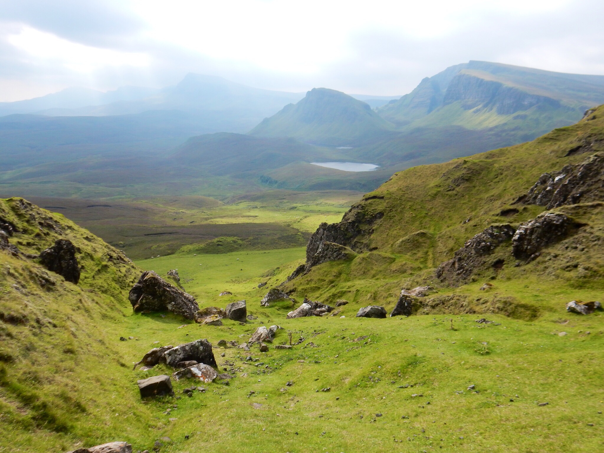
I continued onto a side road to Quiraing, an area of unusual rocky formations in the Trotternish ridge. Parked and hiked for a couple of hours up a steep trail through sheep meadows and then loose rocks to get near the base of the Needle and Prison formations. The views were stunning in every direction.
Day Five: Kippers for breakfast! Toured Dunvegan Castle and its gardens. The castle is still owned by the Macleod clan and the entrance fees help pay for its upkeep. I particularly enjoyed the framed letters from visitors Samuel Boswell and Sir Walter Scott, the memoribilia from Bonnie Prince Charlie and Flora MacDonald, the clan claymore (a big two-handed sword), and various Macleod clan heirlooms, including the Dunvegan Cup, Rory Mor’s drinking horn, and the fairy flag.
There are ferries and then there are fairies. The Macleods entertain several fairy stories regarding the origin of their fairy flag.
One has to do with a Macleod chief marrying a fairy. She eventually left him, but gave him a flag with the instruction to wave it if he or his clan were ever in danger. The flag was good for three rescues. Thus far, it has been used successfully twice. The silk flag, tattered and torn, has been dated by experts to the 300s CE.
Back in Portree, as I was walking down the pier next to my B&B, I heard singing. I pushed into the Pier Hotel’s crowded bar and found two musicians playing traditional Celtic music. In the middle of the set of Celtic songs, they played “Take Me Home, Country Roads” by John Denver. The whole bar sang along. Must be time to leave the islands.
