

Only fourteen percent of the Alps are within Switzerland, yet sixty-five percent of Switzerland is within the Alps. And nowhere but Switzerland are a nation’s culture and the Alps so intertwined.
By Alpine standards, a mountain is high if it crests four thousand meters, just over 2½ miles. Most of the highest and most famous are in Switzerland.
Due to their massiveness, the Alps have long been an attraction. Stone-Agers left behind artifacts. Hannibal crossed with a herd of elephants. The Romans established settlements.
The “golden age” of mountaineering in the 19th century raised awareness of the Alps around the world. Train lines and hotels were built and tourists flocked. Still, residents of the Alpine areas of Switzerland retain a strong cultural identity, based upon mountaineering, hiking, skiing, farming, woodworking, cheesemaking, and, yes, yodeling.
I sampled four of the ranges within Switzerland—the Appenzell, Bernina, Bernese, and Pennine. (To read about the Appenzell Alps, please see a previous post, “More cowbell!”)

Early Christmas
The rain was pouring when I boarded the bus in Lugano. I sat next to a young Japanese woman who works for a travel agency in Tokyo. Her job is to review and recommend hotels, ski resorts, and hiking trails for her customers. Someone has to do it.
The Bernina Express bus travels from Switzerland to Italy, where passengers switch to a train that takes them back into Switzerland.
At the train station in Tirano, Italy, the drizzle was steady. After a slice of apple strudel and a cup of coffee, I waited on the platform, bundled against the chill.
“This is not what the brochure looked like,” I said, attempting a joke with the conductor. I gestured at the rain.
“Ja,” he said, pointing to the mountains, “but I promise it will look like Christmas at the top.”

The Bernina Express features panoramic coaches with large windows, offering tourists postcard views. Over the course of four hours, the train passes through fifty-five tunnels and over nearly two hundred bridges. Most of the route is classified as a UNESCO World Heritage Site.
Early in the journey, the train changed altitude by climbing a famous corkscrew viaduct. Out of the window I could see the front of the train leading the way. For a while, we were in the valley looking up at the high-mountain snow cover. As we continued to ascend, the rain finally stopped. Then we crossed the snow line. The train entered a forest of tall evergreens, beautifully frosted with fresh snow.
The conductor was right. It looked like Christmas. Three months early.

At the top, near Alp Grüm, it was a near whiteout. The Ospizio Bernina station is the highest point of the journey at nearly a mile and a half. It also divides the Italian speakers in the south from the German and Romansch speakers in the north. (Romansch is a language left over from the Romans.)
We crossed the terminal moraine, separating the water flowing to either the Adriatic or Black seas, and descended into the Engadin Valley. My stop was the town of Pontresina.
After checking into my hotel, all dark wood and antlers, I strolled the main street, lined with hiking outfitters, ski shops, and hotels. The restaurants are hidden inside of the hotels, making it difficult to shop menus on the street. At mine, I had mustard-and-beet soup, poached trout, and walnut bread. (In Italian-Swiss Lugano, bread is made with olives. Walnut bread indicated I was now in the Engadin.)

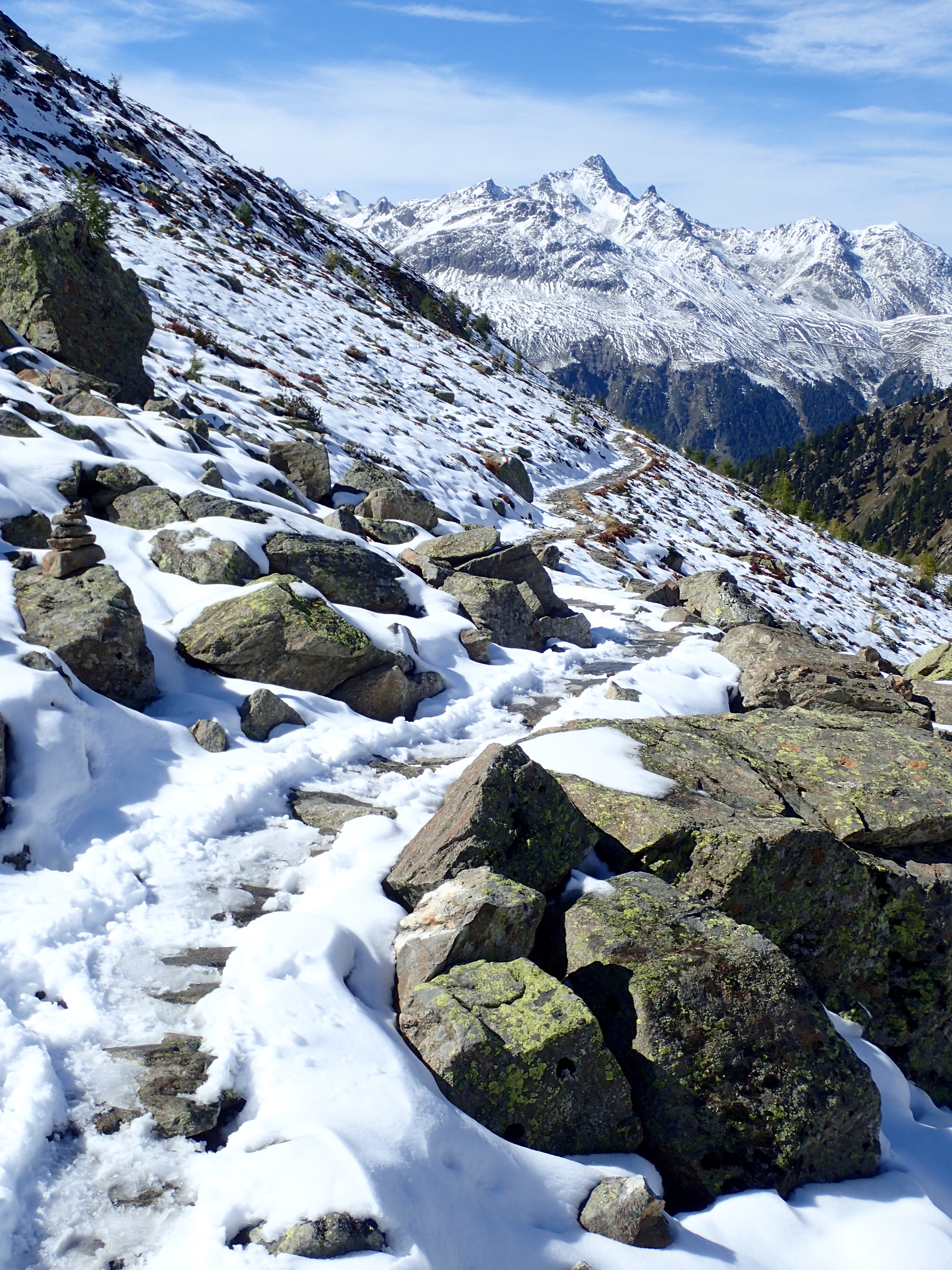
Next day, I used the swipe-able Engadin Card, provided by the hotel, to ride the buses and lifts for free. A nice benefit. I caught the bus just outside the hotel to Punt Muragi Talstation. There, the funicular climbs slowly and steeply to Muottas Muragl, over eight thousand feet high. Halfway up, I was back in the snow.
On top is a lodge and restaurant. Workers were shoveling yesterday’s snow from the deck with the help of occasional sunshine. Much colder and windier, but the view of the Bernina Alps across the Engadine Valley was spectacular.
The Bernina Range in Eastern Switzerland is one of the highest of the Alps, covered with many glaciers. Piz Bernina, at over thirteen thousand feet, is its tallest peak. The Engadin Valley lies at the center of the range. The upper end of the valley cradles a chain of lakes and the town of Saint Moritz, which hosted both the 1928 and 1948 Winter Olympics.
I wanted to hike the trail from Muottas Muragl to Alp Languard, but it was slippery with ice and a long way down. I watched several serious-looking trekkers attempt it and turn back. Another day.
Back in Pontresina, I visited the Burial Church of Santa Maria, a Swiss heritage site. The church is small and covered floor to ceiling with colorful frescoes from the 1200s. Eight hundred years ago, they served the purpose of educating churchgoers who couldn’t read the Bible.
I toured the Alpine Museum, an electic mix of butterfly and mineral collections, stuffed birds, and antique skiing and climbing equipment.
In the conference center next door to the TI, a wine-tasting event was underway. Over twenty merchants were pouring samples for hospitality-industry buyers. As I was chatting with one of the reps (the only one selling an American wine), a group of attendees suddenly began yodeling, Apenzell-style. Appenzell yodeling is slow and mournful, tones not words, featuring beautiful harmony.

When the yodelers finished, the hushed crowd in the hall broke into wild applause. I approached them and told them I had recently visited their canton. (Cantons are like our states.)
They were amazed, as Appenzell is one of the more remote areas of Switzerland. An American in Appenzell! Guter Gott!
Despite the language barrier, they seemed thrilled when I rattled off several Appenzell place names to prove my claim.
The sun emerged the next afternoon and looked like it might linger. The whole town brightened. Mountain bikers raced down the main street, heading for the trails. I hopped on the bus to the funicular station and ascended again to Muottas Muragi.
The trail was in better condition. I headed out, thinking I could return to the lodge if I found it too difficult, but I never looked back. In places the path was icy, snowy, slushy, muddy, or rocky. Sometimes the precipice was so steep, I was afraid to look up or down. I encountered only a few other hikers. One was sitting at an overlook, smoking.
The air was clear and the sun bright. I didn’t need the extra gear I packed, the hat, gloves, or gaiters. In fact, I grew warm and stowed a layer. I could easily pick out Saint Moritz and its neighbors down in the valley. The series of lakes sparkled like jewels on a necklace. Tiny cars and trains threaded the green valley.

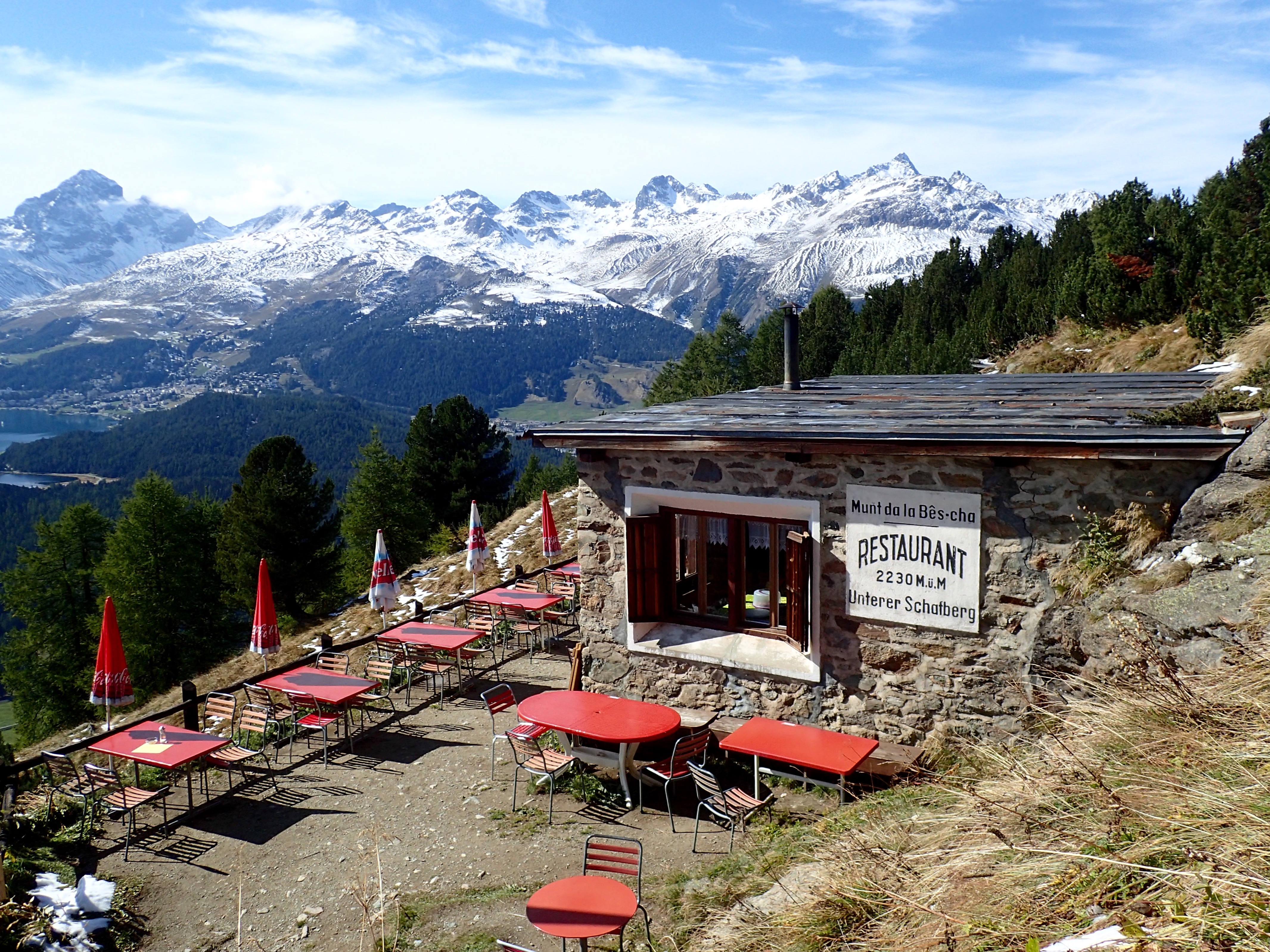
Midway, I left the snow and rocks behind and climbed in and out of the trees. In places, water cascaded down chutes. I reached Munt da la Bêscha, a small primitive café overlooking the valley. I took a break on its patio. And visited its famous rustic outhouse.
I arrived at Alp Languard late in the afternoon. Jumped on the ski lift and, a few minutes later, I was walking the streets of Pontresina again, looking up at the snowy mountains.
All about the ‘Horn
There are the Alps and there is the Matterhorn.
It is perhaps the most recognizable mountain in the world, an icon commanding the landscape and demanding everyone’s attention. Although only the tenth highest mountain in Switzerland (at nearly fifteen thousand feet), it is the most dangerous for climbers.

The Matterhorn is in the Pennine Alps, home of dozens of bucket-list summits in western Switzerland near the border with Italy.
To get there from Saint Moritz, I boarded the Glacier Express, another panoramic train. The Express connects eastern Switzerland with Zermatt in the west. Express is a stretch, as the plodding journey takes over seven hours.
During the course of the day, the train navigated nearly three hundred bridges and ninety tunnels. It performed acrobatics, traversing six aqueducts, three spiral tunnels, and two helical tunnels.
We passed high green pastures, Swiss-brown cows, wood chalets, ski runs, craggy peaks, and avalanche fences. The Rhine River in this stretch is a shallow trout stream. I napped in the eleven-mile Furkatunnel.
Finally, we began the steep ratcheted climb to Zermatt. Black larch-wood huts—log cabins with stone foundations and rock-shingle roofs—dot the valley.
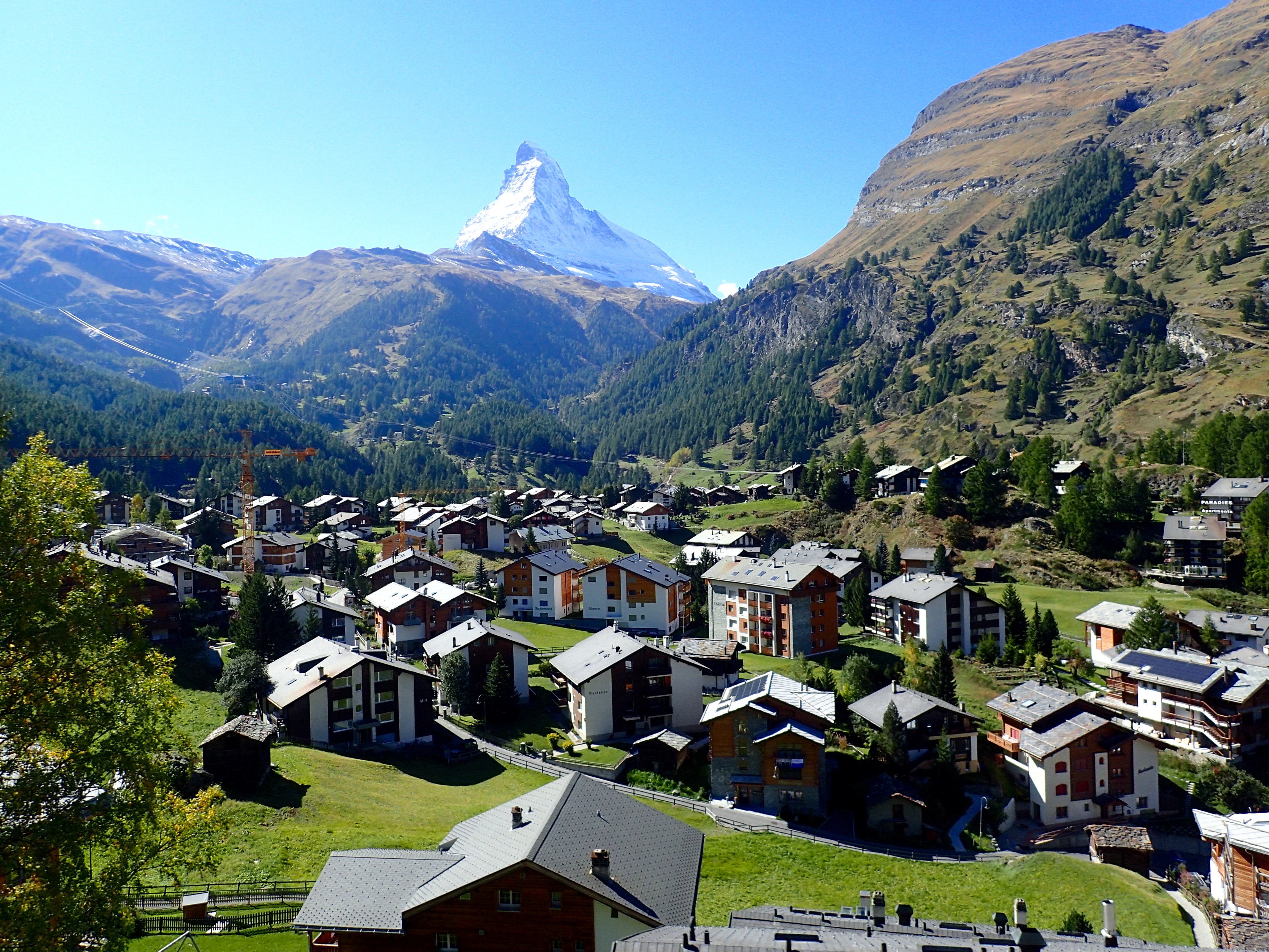
Zermatt with a population of six thousand is in a German-speaking canton. A mile high, it is a mountaineering and ski resort on steroids. Until the 1800s, it was a farming community. The tragic first ascent of the Matterhorn in 1865 changed all of that.
No cars are allowed in town except for taxis and commercial vehicles, which are electric and only slightly larger than golf carts. Checked into my hotel with the Matterhorn looming above. The amenities are basic. A rack for hiking boots near the front door. Comforter and down pillow only. No TV.

Next day, I wanted a closer look at the ‘Horn, as the mountain is called. I took the multi-staged journey to Rothorn. Stage one is a funicular ride through a tunnel in a mountain, much like Spaceship Earth at Epcot. When the train arrived at Sunnegga, I walked unsteadily up the steep steps to the restaurant.
The view was incredible, not just of the Matterhorn, but of the surrounding area.
Of course, the unique jagged shape of the Matterhorn, like a shard of glass, draws the eye. I sat outside with a cup of coffee in awe of it. Then stage two—a gondola ride to Blauherd. After a brief look around there, I traveled the final stage—a cable car to Rothorn. Several hikers and mountain bikers rode the stand-up lift as well.
On top, I spent a couple of hours staring at the Matterhorn from different angles. The altitude, at 2¾ miles high, winded me just moving around. Breathtaking, literally.
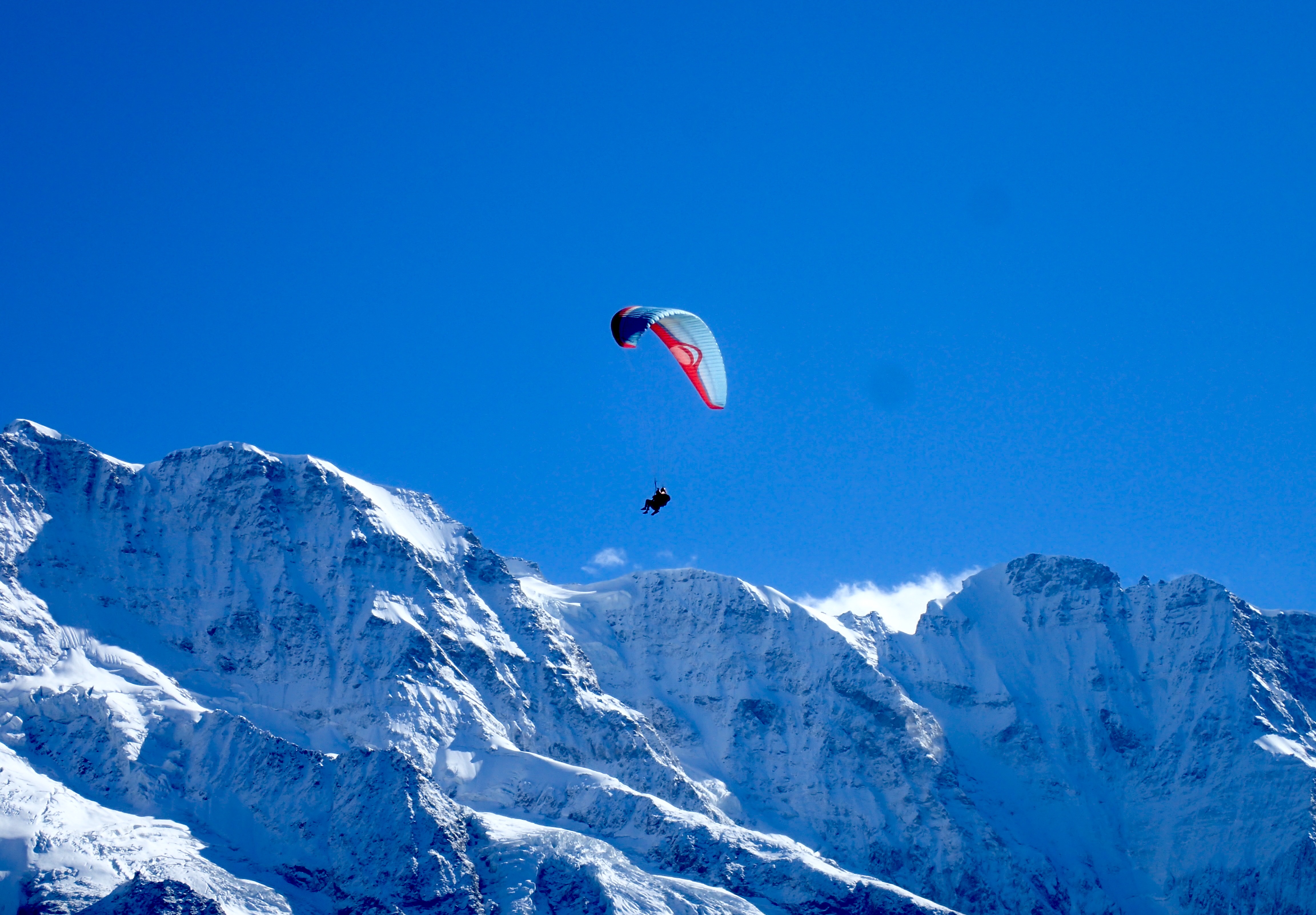
I spotted several glaciers glistening in the sun. A dozen or more paragliders soared from the heights over the valleys. A short trail at the top identifies each mountain on the horizon and commemorates some of those who have died climbing them. The tallest is Monte Rosa at over fifteen thousand feet. But the Matterhorn’s history outdraws the rest.
Many thought the Matterhorn was unconquerable.
However, in July 1865, a party of seven English, Swiss, and French mountaineers of varying experience succeeded. Most were in their late teens and twenties. Shortly after summiting, tragedy struck.
As they were descending, one of the climbers slipped. His weight dragged three more after him into the abyss.
The rope snapped when they fell, and the lives of the three remaining climbers were spared.
The Matterhorn was the last “golden-age” Alpine peak to be summited.
The three survivors gave widely different accounts of the accident. They were later accused of having cut the rope to ensure their survival, but were acquitted. To this day, no one knows what actually happened on the mountain.

However, there can be no question that the accident caused an avalanche of tourism in Zermatt. What was once a sleepy farm town at the end of a long valley became an international destination for climbers, skiers, and tourists.
On the way down at Blauherd, a herd of photogenic Valais blacknose sheep made friends with the tourists. They approached me and nudged me to be petted. Fluffy and white with black heads, knees, and tails, they look like plush toys.
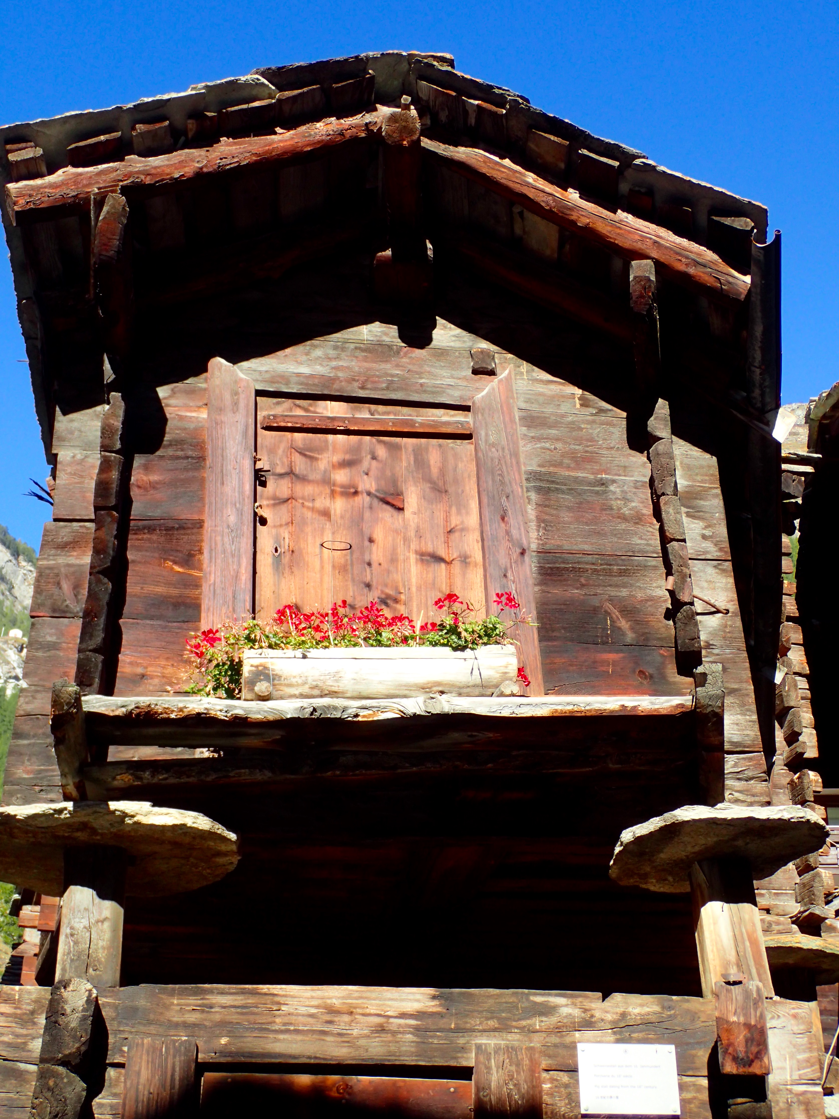
Back in Zermatt, I toured the larch-wood huts in the Hinterdorf area. They were built without nails in the 1500s and 1600s. Larch is an exceedingly hard and pest-resistant wood that turns black with weathering. Just one hundred and fifty years ago, these huts were all there was to Zermatt.
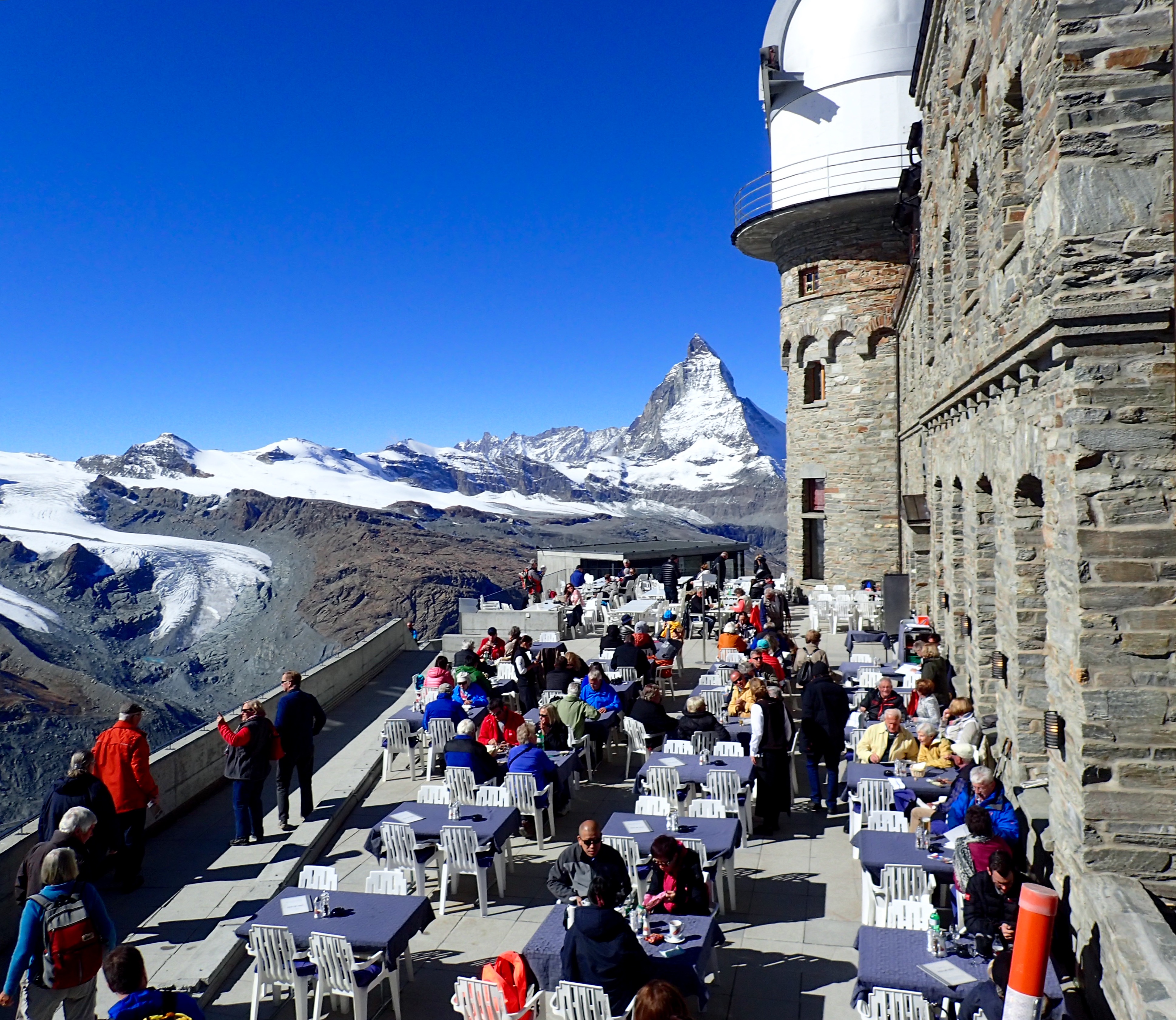
The next day, I took a cogwheel train to Gornergrat.
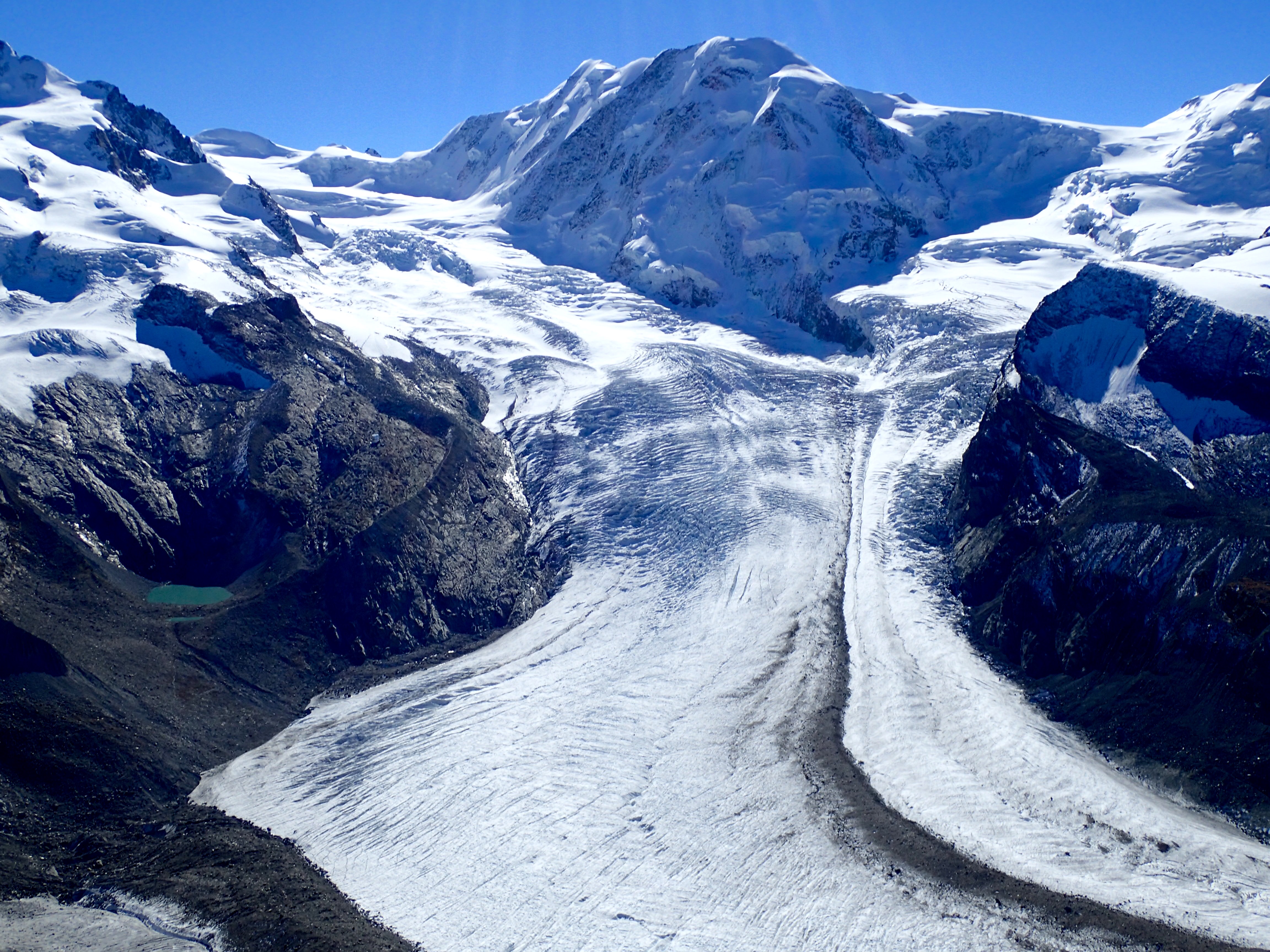
Hikers got on and off. The viewing platform at Gornergrat is ten thousand feet high with great views of the ‘Horn, Monte Rosa, and the Gorner Glacier, as well as numerous other peaks, all resembling broken pieces of gray pottery.
I hiked a red trail (difficult) downhill to the next station. Saw several milky-green glacier lakes, including Riffelsee that reflected the Matterhorn. Arrived at Rotenboden (nine thousand feet) and took the train the rest of the way down. A good workout.
Back in Zermatt, I ate dinner at the oldest restaurant in town, Café du Pont, a low-ceilinged hut with pine panelling and accordion music. Veal sausage and rösti (hash browns), salad, cheese, and bread.

Since the tragedy in 1865, over five hundred people have died climbing the Matterhorn. About four thousand climbers make the attempt to summit each year. Forty percent (mostly those with personal guides) succeed. Ten to twenty climbers die annually. Swiss officials are working to reduce the number of attempts.
The talkative owner of a local restaurant told me about the man and dog who look around the bases of the mountains each spring for the corpses of dead climbers.
I asked if the Zermatt community was blasé, given the number of climbing deaths each year. “Not if it’s a local person,” he said.

He reminded me the town is a center for extreme sports. Extreme sports are called extreme for a reason, he said. Tourists who participate are expected by the locals to understand and accept the risks.
The Matterhorn Museum in Zermatt is celebrating the one-hundred-and-fifty-year anniversary of the first ascent with a special exhibition. On display in a glass case is the broken rope.
Zermatt is a Wild West town.
Mountain guides, cyclists, paragliders, ski instructors, and railroad workers. They stand in the doorways of bars, lean, mean, tan, bearded, wearing a disheveled assembly of outdoor gear, smoking like Marlboro men, managing, like lions, to look both indifferent and poised for action.

“I am so small”
Imagine the street where you live sitting on the edge of a cliff. This is Gimmelwald.
A tiny, fairy-tale village of one hundred and twenty residents, Gimmelwald clings to the side of a mountain at four thousand and five hundred feet. It gazes across a deep valley at a mountain range, covered in snow. Only one lane runs through the town, lined with forty or so larch-wood huts, blackened by time and weather. Window boxes overflow with geraniums. Wood is tightly stacked. Cows and goats clang their bells.
There are two restaurants in town, one of which is closed for the winter. I’ll be eating at the other.

To get to Gimmelwald, I took a train to Montreux, a train to Zweisimmen, a train to Interlaken Ost, a train to Lauterbrunnen, a bus to Schilthornbahn, and a cable car up the cliff to Gimmelwald. The journey was pleasant despite all of the connections. The Golden Pass, a panoramic train, rambled past rows of brown and green chalets stair-stepping up the hills below jagged mountains. Pale-blue glacier water splashed down creeks full of boulders. The sun came out and, with it, the color.

The cable car from Schilthornbahn was packed, maybe sixty people, all standing. Several were paragliders, returning to the top for another jump. As we climbed, the cliff face seemed only inches away.
A key was left for me at the guesthouse. I stowed my bags and then explored Gimmelwald. This took all of five minutes. I sat at an overlook and tried to absorb the grandeur of what I was seeing.
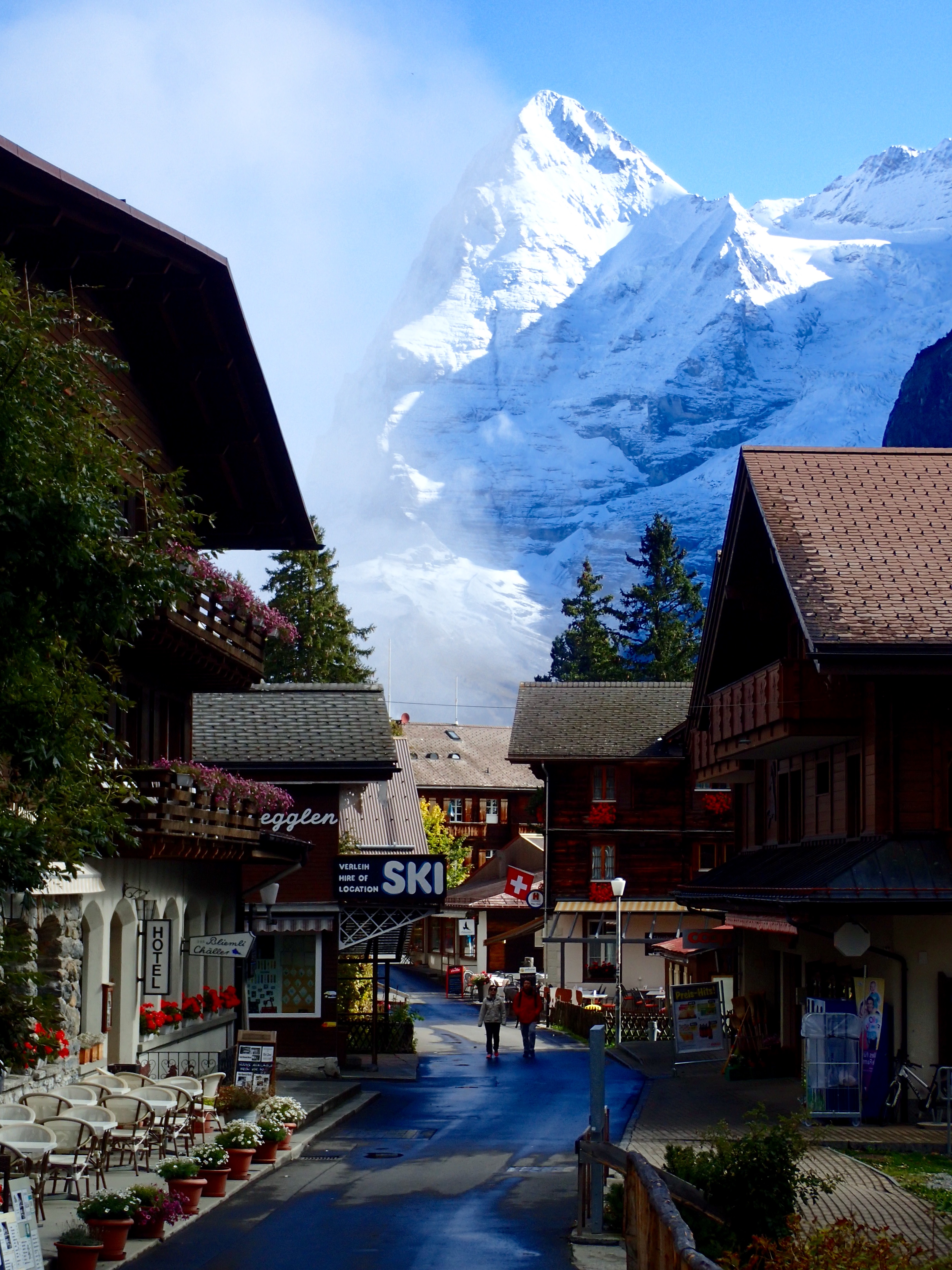
The Berner Oberland region features a selection of the Bernese Alps. Three mountains, Jungfrau, Mönch, and Eiger, align to form a massive six-mile-long wall that towers over the villages in the valleys. Waterfalls plunge hundreds of yards before dissipating into spray. The only sounds are rushing water and rattling cowbells.
At breakfast the next day, another guest, an American ex-colonel, raved crazily about his Berner Oberland experience. The mountain views, the hiking, the solitude. It had been life-changing for him. By the end of the day, I understood.
I hiked, first uphill to the village of Mürren, then along a flat course to Winteregg and Grütschalp. Five hours round-trip, including a stop for a picnic lunch, packed by the guesthouse. The forest is mostly spruce, plus larch, sycamore, and chestnut. A sign said the average incline of the slopes is eighty percent.
Hikers and dogs greeted me on the trail. Some, usually the Americans, stopped to talk. I spotted what I thought were small deer, a herd of seven. Wisps of clouds played magician with the mountaintops, making them disappear and reappear. Slowly the fog lifted from the valley.

Finally, by mid-afternoon, the sun became a fixture. I took photos of Eiger, Mönch, and Jungfrau, the three mammoths side by side, all over thirteen thousand feet. Paragliders and cable cars sailed overhead.
At dinner, the owner of the Mountain Hostel Restaurant convinced me to try the special, roast deer, pasta, brussels sprouts, chestnuts, red cabbage, a baked apple, and salad. I asked her about the deer.
“I don’t know what you call it in English,” she said. “We call it Gämse (chamois).”
“I think I saw some today,” I said.
“Ja,” she said. “The lucky ones.”
The next day, I day-tripped to Grindelwald (not to be confused with Gimmelwald) in the next valley. Despite connecting from cable car to bus to train to train, the trip took only an hour. Swiss transportation is punctual.

I waded through a throng in Grindelwald, in town for the annual market. The streets were filled with vendors selling sausage, cheese, clothing, toys, crafts, and so on. State-fair food and rides for the kids. The restaurants were packed. Bands played.
The cable car up to Pfingstegg offered an incredible view of Grindelwald on the valley floor. At the top was a luge ride for kids. I hiked most of the way to Bäregg, reaching sight of the Grindelwald Glacier at the foot of Schreckhorn. As the terrain became steeper, the trail narrower, the footing less certain, and the afternoon later, I decided to return to the festival in Grindelwald for dinner.
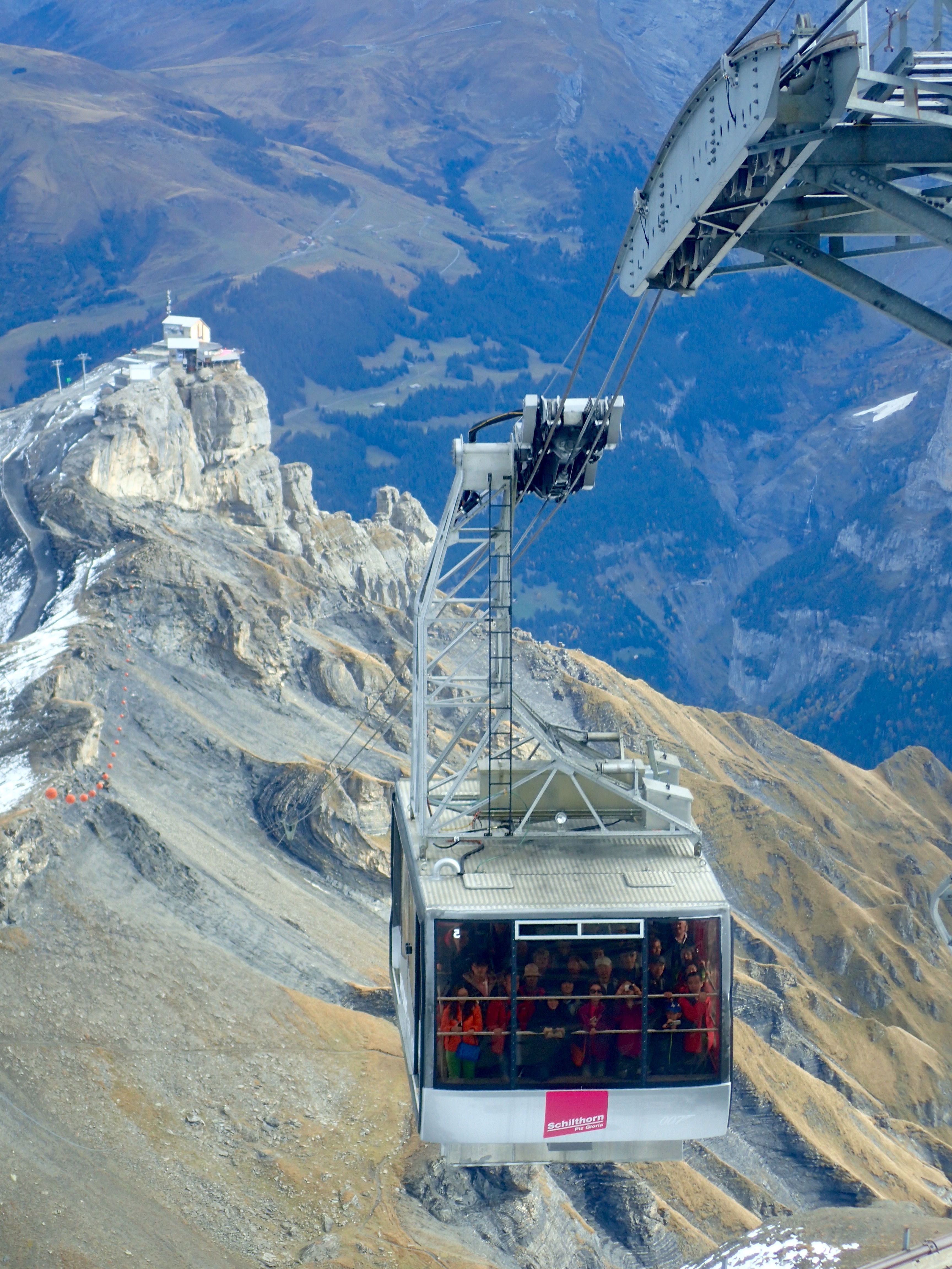
The next morning in Gimmelwald, people were clearing their gardens for winter. I headed to Schilthorn, nearly two miles high. The price was as steep as the cable-car ride—eighty francs round-trip from Mürren—but it was exhilarating. The cable car soared over the mountains.
At the windy, frigid summit the view was three-hundred-and-sixty degrees, the highest peaks white with snow, the valleys brown and barren above the tree line.
The entire station at Schilthorn is James Bond-themed, because the 1969 movie, In Her Majesty’s Secret Service, was filmed there. Unfortunately, the film’s action sequences don’t hold up, as they were all green-screened with the stars. Locals performed the actual skiing and sledding scenes.

The filming of the movie must have created quite a stir in this remote area. The population of Mürren was about equal to the one hundred and fifty members of the cast and crew. The production helped fund the build-out of the restaurant, Piz Gloria, at the station. I posed with a life-sized cutout of the star, George Lazenby.
Next morning in the rain, I took the cable car down to Schilthornbahn. The operator was excited about the fall color. Nice to see you can live here and not get bored with the beauty.

Toured Trümmelbachfälle, a series of waterfalls gushing through the inside of a mountain. The melt from the glaciers around Eiger, Mönch, and Jungfrau all drain through this one channel.
To see the falls requires climbing several stories of stairs and passing through tunnels. The water doesn’t fall straight but water-slides through the crevices it has carved inside of the mountain. Over five thousand gallons of water roar down each second.
Later, after dinner in Mürren, I walked back downhill to Gimmelwald. On the trail I caught up with a young Chinese man, perhaps twenty years old, surveying the valley.
We chatted for a minute about the view, pointing out the mountains, the clouds in the valley, the yellow maple leaves, the waterfalls and streams. The immensity of it all.
He was visibly moved by what we were seeing. We stood for a moment in silence, overwhelmed by the vastness of nature.
“I am so small,” he said quietly. “I am so small.”

Thank you for this wonderful narration- I am testing kids ( 5th graders) with Terra Nova tests – and had time to read your wonderful narrative – and live vicariously !!! What an experience you’re having! Thanks again!
Stunning photos and wonderfully descriptive narrative. Thank you!