

Near the west coast of the Olympic Peninsula, four rivers converge to form one.
They are the Bogachiel, Calawah, Sol Duc, and Dickey, and, when flowing together, they compose the Quillayute. At the village of La Push, Washington, the Quillayute River empties into the Pacific Ocean.
La Push, with a population of two thousand, is home to the Quileute tribe, the river’s namesake.
The tribe’s original territory stretched across the western half of the peninsula, from Mount Olympus to the seacoast. Traditionally, the Quileute were skilled whalers and seal hunters. After signing a treaty in 1889, the tribe was forced onto a one-square-mile reservation.
Quileute is the name of both the tribe and the village where La Push now stands. The word may mean wolves. The Quileute origin story tells how a wandering “transformer” turned two wolves into the two humans who founded the tribe. Wolves feature prominently in Quileute culture.
And also in Twilight Saga.
Author Stephenie Meyer took inspiration from the tribe’s heritage in her series of fantasy romance novels. In the series, the teenage heroine, Bella Swan, moves near to La Push and falls in love with a vampire.
Fictional members of the Quileute tribe are portrayed as werewolves. The success of the Twilight franchise brought some fleeting awareness to the Quileute—but no compensation for “borrowing” the the tribe’s history and culture.

Eagles and Forks
After fourteen months of COVID-19 restrictions, my friend Leslie and I were looking for an escape. We discovered a non-stop flight that once a day connects Columbus with Seattle. The Olympic Peninsula looked like an ideal destination to explore.
The peninsula is bounded by Puget Sound on the east, the Strait of Juan de Fuca on the north, and the Pacific Ocean on the west. Ice Age glaciers separated it from the mainland and centuries of isolation enhanced its biodiversity.
The Olympic Peninsula was one of the last unexplored places in the contiguous United States. At its center is Olympic National Park. President Theodore Roosevelt named Olympic a national monument in 1909. It encompasses one million acres. Unlike most national parks, no roads pass through Olympic. To access trailheads requires driving around the park’s perimeter.
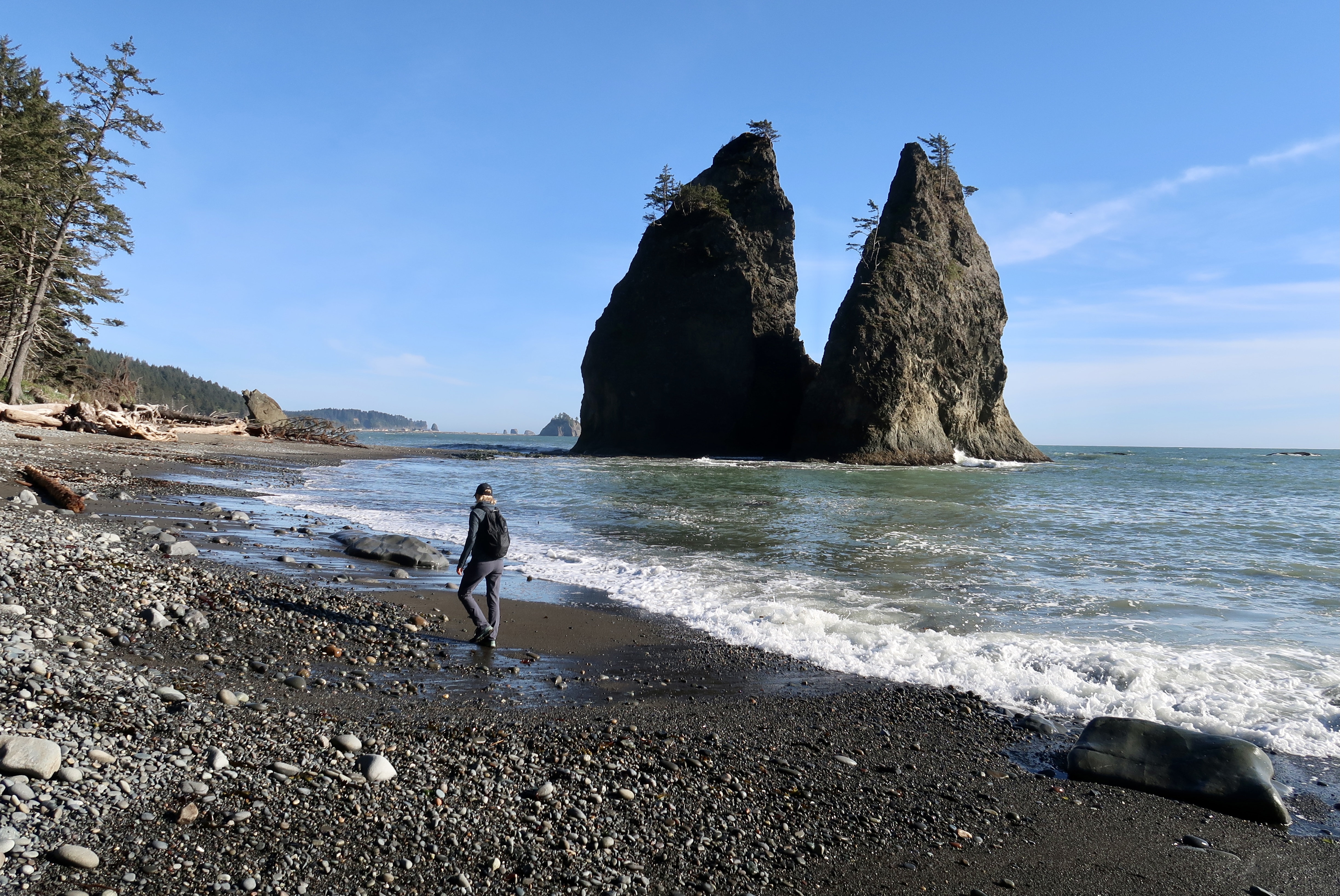
We headed first to the west side, where the park includes sixty-five miles of wild Pacific coastline. The rugged beaches are strewn with boulders and driftwood. Sea stacks punctuate the horizon.
For our first hike, we chose Rialto Beach, just north of La Push at the mouth of the Quillayute.
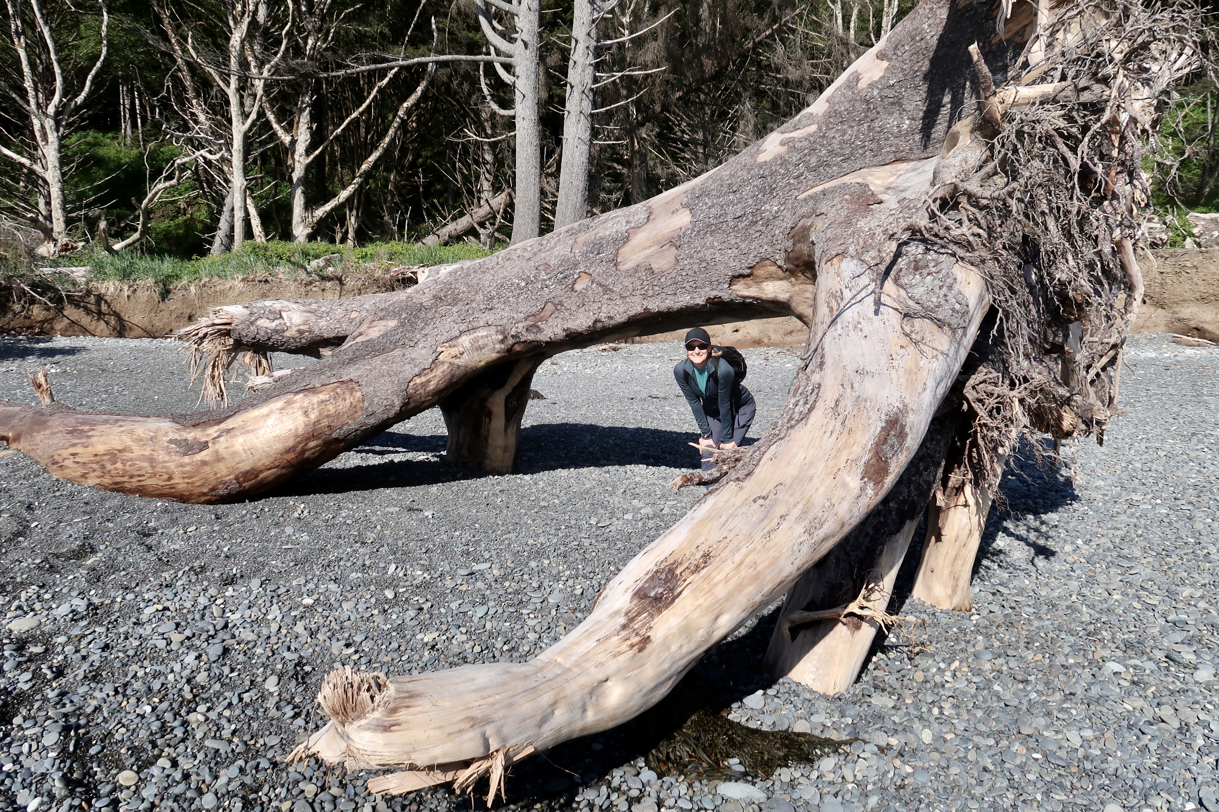
Rialto is piled with pebbles, which are polished smooth by crashing waves. The bleached trunks of massive trees litter the beach. They look like the leg bones of colossal dinosaurs, gnawed as if at a terrible feast.
Climbing over the logs, we crossed a small river and hiked roundtrip to the Hole in the Wall. The hole is an arch in a rock fin, carved by the sea. During low tide it is possible to pass through the arch and reach the beach on the far side, but, for us, the tide had turned.

We headed back to the car, as campers arranged their tents among the stranded driftwood, fired their cookstoves, and settled for the night.
The wind roared. Waves sloshed over the tidal pools. Overhead, a crow clenched a wriggling crab in its beak and carried it inland for dinner.
Like teenagers looking for action on Saturday night, bald eagles took turns cruising down the Quillayute River. We spotted three of them in a matter of seconds. They seem as common as robins in Ohio.
We headed to Forks, just inland from La Push. The town is named for the confluences (or forks) of the four rivers that form the Quillayute River. Forks has a population of four thousand and consists of a few blocks of small buildings clustered around US 101. It is the rainiest town in the contiguous United States.

Once a logging community, Forks, like La Push, is also known as a setting for Twilight Saga—the domain of the vampires.
The town served as our base for the park’s beaches and rain forests. Vampires were perhaps working the evening shift at Thriftway where we bought our supplies.
Elves and elk
Early the next morning, we drove into the Hoh Rain Forest. The Olympic Peninsula’s west side receives an average of one hundred forty inches of precipitation each year, making it one of the wettest areas in the contiguous United States.
Olympic’s rain forests are dominated by evergreen trees—spruce, hemlock, Douglas fir, and red cedar. The trees tower over the forest floor, blocking most of the light. Moss and lichen coat their trunks and drip eerily from their branches. At shoulder level is a forest of lush ferns.
The affect is either enchanting or gloomy, depending upon your perspective. Leslie was reminded of the forest of the elves in The Lord of the Rings.
Hoh is home to bobcats, cougars, black bears, black-tailed deer, spotted owls, tree frogs, and banana slugs. We walked silently on fallen needles and avoided slipping on the bananas.
The overcast sky only heightened the mysteriousness of the valley.
Several times we took side trails to the shallow Hoh River and walked onto the gravel bars. The snowcapped Olympic Mountains hovered in the distance.
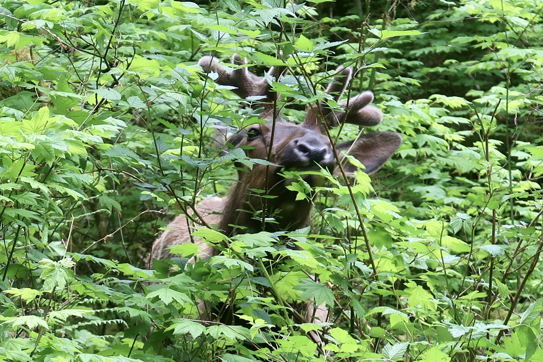
Then, on our way back to the visitor center, we passed a male Roosevelt elk calmly munching leaves just ten feet from the trail. Before beginning the hike, we read a notice at the visitor center warning hikers to be alert for aggressive elk. Bulls may grow to 5½ feet in height and 1,100 pounds in weight.

During the fall mating season, males are juiced on testosterone and can be dangerous. In the spring cows will defend their calves from humans who venture too close.
Combative elk are sometimes tranquilized and relocated. Repeat offenders may be euthanized. The notice asked hikers to report aggressive hikers as well as aggressive elk. (After all, one of the reasons President Roosevelt established the park was to protect the elk from humans. It may be why they are named for him.)
Our elk was not aggressive, but rather engrossed in eating. A few hikers stopped to watch and take photos. As we neared the visitor center we passed a trio of park rangers headed into the forest with tranquilizer guns. We hoped their intent was to sedate and relocate the hikers.

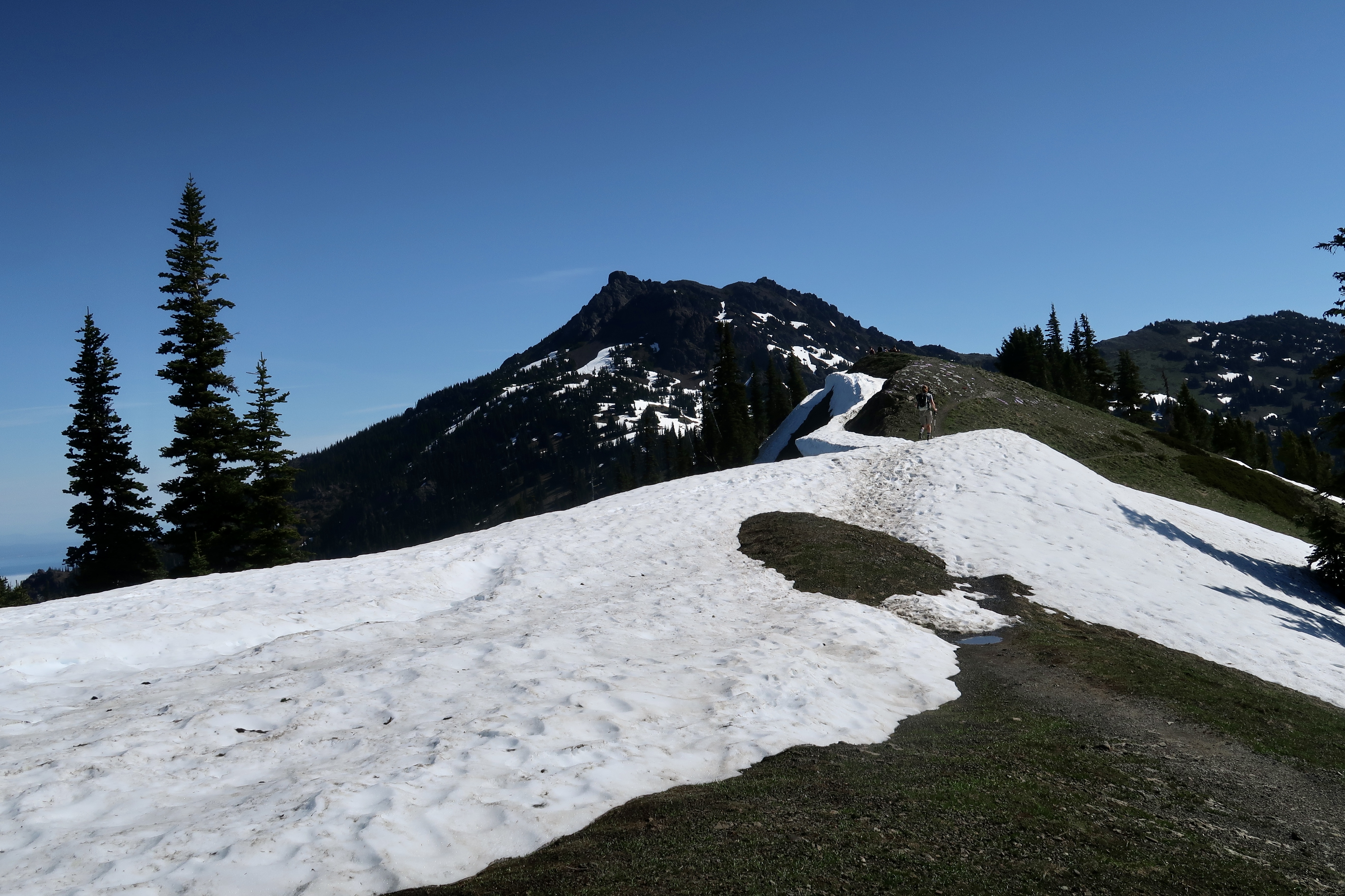
The King and I
We left Forks at 6:30 a.m. Today’s objective—the summit of Mount Storm King. Even the name is scary.
The steep incline began as soon as we stepped onto the trail.
The path to Mount Storm King is a jumble of rocks, twisted roots, and loose gravel in a forest. The trail climbs two thousand feet over 2½ miles, an almost fifteen percent grade. The mountain tops out at 4,525 feet.
We were among the first to start. Hardly anyone else on the trail. For a couple of hours we climbed straight up. My lungs were bursting, my heart racing, and my clothes drenched with perspiration. Leslie seemed unfazed.
Soon some younger hikers caught us, but as they gained elevation, they lost momentum, and we took turns leapfrogging each other. One young man looked wearily at me as we paused at a switchback to catch our breath and said, “This is kicking my ass.”

The climb seemed endless, but finally we reached a wood sign that read End of Maintained Trail.
Past the sign, we scrambled along a narrow rocky ridge until we found a knotted rope dangling down the side of a rock face. It was the first of seven roped sections.
Only one person can climb a rope at a time, so our small group took turns.
When it was my turn, I planted my feet, flexed my knees, leaned back, and walked myself hand over hand, knot by knot, up to the next fixed rope. The footing was solid in places, slippery in others.
At the top of the roped sections, Leslie continued to scramble up the rocks to the promontory, just a few feet above. Instead, I rested. After the long climb, my knees were too shaky to navigate the sideways slant of the scramble. One misstep would have sent me over the side. At the top Leslie enjoyed a sweeping view of twelve-mile-long Lake Crescent and the Strait of Juan de Fuca.

Lake Crescent was once larger. Geologists say eight thousand years ago a landslide divided the lake in half, creating a second lake called Sutherland.
The Klallum tribes have a different story. Their legend is that the Storm King expressed his anger at two warring tribes by throwing a boulder into the lake and splitting it in two.
The return trip to the bottom was almost as difficult as the climb. While backing down the rope course on the mountain’s face, I couldn’t see where to place my feet. Hikers above dislodged stones accidentally that clattered down the slope toward me.
At the bottom of the ropes, a line of hikers were nervously awaiting their turns to climb. The hike down the mountain was easier on the heart and lungs, but tougher on the knees. Total distance: 5.3 miles. I was glad to reach level ground.

Ridges and spits
We chose Port Angeles, a city of twenty thousand, to be our base on the north side of the peninsula. The city sprawls down the slope from the highway to the harbor. It is home to the park’s headquarters.
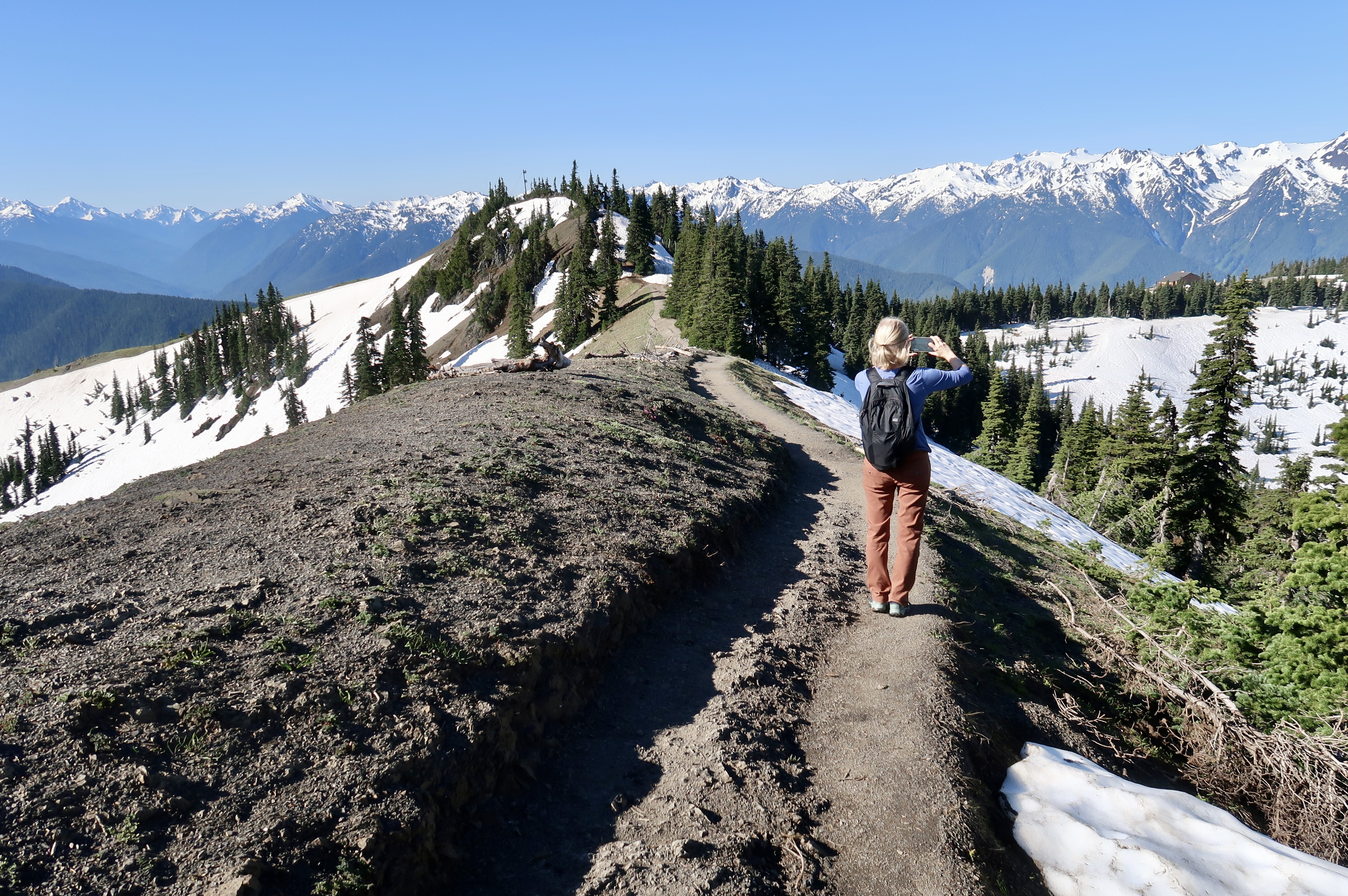
Early the next morning we drove up Hurricane Ridge Road, stopping occasionally to take photos of the snow-topped Olympic Mountains. The western half of the range is dominated by Mount Olympus, which rises to nearly eight thousand feet.
On Hurricane Ridge wind sometimes gusts to seventy-five miles per hour; thus, its name. An average of thirty-five feet of snow falls per year. When we arrived at the visitor center, black-tailed deer were grazing on the slopes and licking soft-drink spills from the parking lot.

We hiked the Hurricane Hill Trail, steep in places but with spectacular views. The trail starts in a pine forest, then switchbacks above the timberline into a high meadow. Snow covered the trail in shaded sections.
Near the top, a marmot stood up like a prairie dog. The climb topped out at almost six thousand feet with views of the craggy Bailey Range, Port Angeles, the Strait of Juan de Fuca, and Vancouver Island.
In the afternoon we relaxed in the town of Sequim (pronounced skwim). The town is in the rain shadow of the interior mountains and receives less than sixteen inches annually. (Compare with the Hoh’s annual precipitation of one hundred forty inches.)

The area is known as the Lavender Capital of North America.
Lavender’s essential oil is used as an ingredient in cosmetics and cooking. We stopped by Purple Haze, a lavender farm, and walked its gardens.
The area is also known for Dungeness crab. The species ranges from Alaska to California, but is named for Dungeness, Washington, just five miles from Sequim.
We visited the Dungeness National Wildlife Refuge and walked a ways on the spit. The Dungeness Spit juts from the peninsula into the Strait of Juan de Fuca for five miles and grows a few feet more every year. It is the longest natural sand spit in the United States.

Near the tip is the New Dungeness Lighthouse, operating continuously since 1857. Across the water, majestic Mount Baker provides the perfect scenic backdrop. Baker is the third-highest mountain in Washington and the fifth-highest in the Cascades.
The bay serves as a shelter for shorebirds and waterfowl. We spotted a couple of bald eagles perched on high limbs along the banks.
Eight tribes have traditional connections to lands now in Olympic National Park. They are the Quileute, Hoh, Makah, Quinault, Skokomish, Port Gamble S’Klallam, Lower Elwha Klallam, and Jamestown S’Klallam.
The latter owns Stymie’s, a restaurant at the Cedars at Dungeness golf course, where we enjoyed small plates of local seafood—Dungeness crab cakes, Manila clams, and cod tacos.
PTs and cougars
Again the next morning, we were the first to arrive at Hurricane Ridge. We waded up the snow-covered ski slope to the High Ridge Trail and followed it to Sunrise View Point. Then, below the view, we joined the Hurricane Ridge Trail toward the 6,454-foot Mount Angeles.
The path traversed high meadows and rocky outcroppings. In a few places, I scrambled on slippery snow banks.
A group of seven recent college graduates passed us, all female physical therapists. It sounds like the beginning of a joke, I know. I felt somewhat relieved to have them close at hand.
After a few miles, we all stalled at an intersection with a spur trail. The way toward Mount Angeles was covered in snow and impassable. After snacking on energy bars, we returned to the visitor center.
While looking for more hiking opportunities, we explored the north coast of the peninsula. West of Port Angeles we found the Salt Creek Recreation Area and the remnants of two World War II bunkers.
Camp Hayden was an artillery camp established in 1941 to protect the coast. The gun batteries included two six-inch guns and two sixteen-inch guns. The larger guns had forty-five-foot-long barrels and could fire twenty-eight miles.
The post was abandoned by the US Army in 1948.
While at Salk Creek we hiked a portion of the Striped Peak Trail to a quiet cove and had it all to ourselves. A sign at the start warned of a cougar in the area. Another notified of a missing pet cat. Hmm.
Locked gate
Over the course of our stay, we hiked other trails in the park, including Third Beach with its rope ladders and Marymere with its ninety-foot waterfall.
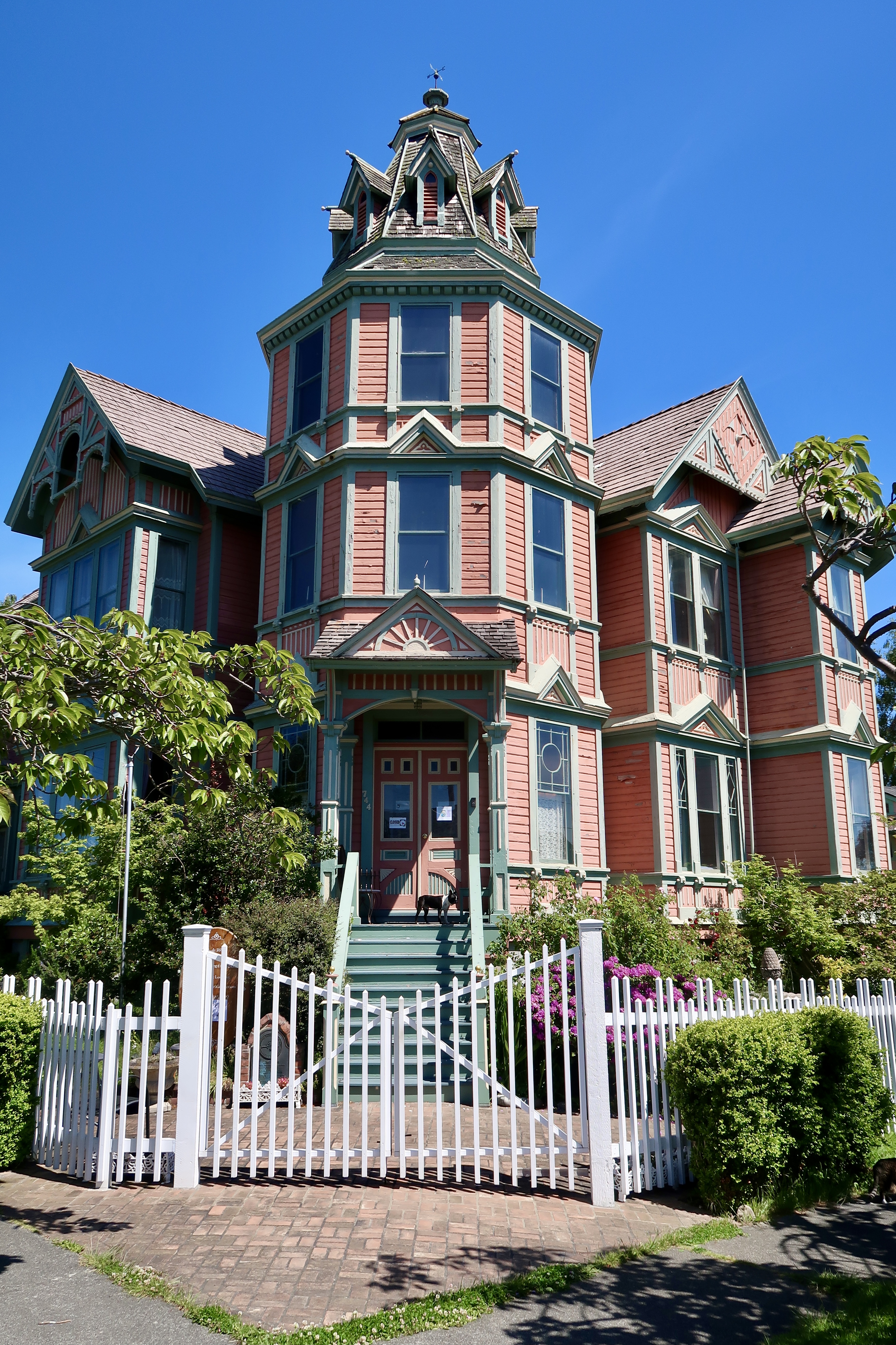
A pleasant day was spent at quaint Port Townsend. The city of nine thousand is located at the northeastern tip of the peninsula. Port Townsend was once predicted to become the largest harbor on the west coast of the United States.
Speculators built fancy homes and offices. The city’s well-preserved Victorian-style buildings from the 1800s earned it a National Register Historic District designation.
Port Townsend is nicknamed Key City, because it stands guard at the gate to Puget Sound. Currently, however, the gate is locked and the key is stashed, as ferries to Canada sit idle in the harbor and wait for the end of COVID-19 travel restrictions.

Watch out for vampires.
Hi stranger! When I saw YearTripper on the incoming, I didn’t read further at the moment—I will, of course—momentarily. I’ll hope to find all kinds of questions answered, but at this minute, I want to say how good it is to know you’re well and still on the move. Wherever you are now, I hope I’ll find out forthwith. Right now, I’m just glad to hear from you!! John
Glad you are back on the trail, Kirk!
Kirk, so happy to hear from you and glad that you are able to continue to pursue your travels. Also passing along regards from the members of the 4As Diamond Forum. We miss you much. Safe travels and hope to hear from you again soon.