

The clerk at the airport’s car-rental center reviewed traffic laws and driving tips with me.
“Park the car facing into the wind,” she said, “so that your door doesn’t get blown off when you open it.”
She continued. “Leave the headlights turned on at all times while driving. Spaces are available in the one-lane tunnels to pull over when vehicles approach from the other direction.”
There was more. She cautioned me regarding crosswinds, flooding, sandstorms, snow and ice, blind curves, blind summits, gravel roads, one-lane bridges, and animals in the road.
Was I about to embark on the Ring Road or the Oregon Trail?

Circle back
I bypassed Reykjavik, saving it for the end of the trip, and drove straight to the village of Borgarnes, the gateway to the Snaefellsnes Peninsula. All the way, thirty-five mile-per-hour gusts buffeted the car.
The first time I visited Iceland was in 2012, along with my friends George and Lynne. George and I were there to run the Reykjavik Marathon. After the race, my friends left for home, but I stayed a few extra days. In a rental car I drove around the Snaefellsnes Peninsula and as far as the town of Akureyri on the northern coast.
I was so taken with Iceland’s jaw-dropping scenery, I vowed to return and tackle Route 1, the Ring Road, an 821-mile loop that circles the island.

Thirteen years later, I am back on the Ring.
Route 1
The country of Iceland is roughly the size of the state of Ohio. The Ring Road connects many of the villages around its perimeter. In between, however, are long stretches of breathtaking scenic beauty. The road rambles past glaciers, volcanoes, fjords, waterfalls, and canyons. The Atlantic Ocean is often in view in the east and the south.
Route 1 has thirty-one single-lane bridges. The first vehicle to the bridge has the right of way. In the more rural areas sheep, goats, and cows amble across the road.
Most of the route is in good condition. However, compared to interstate highways in the United States, the lanes are narrow. There is no berm. Once you commit to driving, there are few places to pull to the side, except private drives to farms. Nowhere to take a break or check your navigation.
Much of the road is built on a raised, steeply banked bed of cinders, volcanic probably. One wrong move and down the embankment I go. In the mountains it’s over the cliff I go.
Sometimes it seemed as though I were driving on the edge of a knife.
Gale force
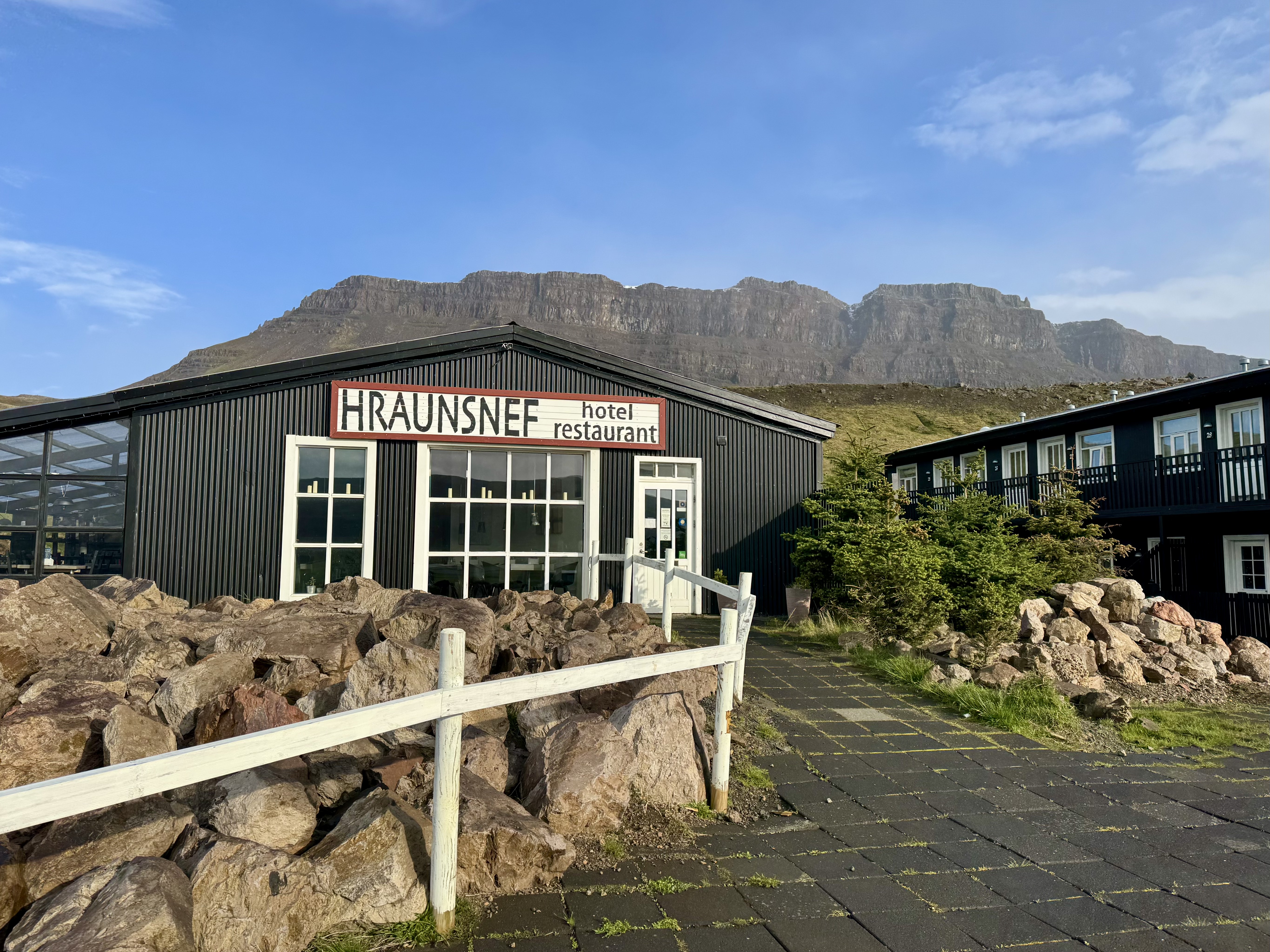
When I pulled into the driveway of a country hotel on a working farm north of Bogarnes, I was greeted by a ewe and two spring lambs.
Icelanders are skilled at repurposing their properties for tourists. Three of my overnight stays were on farms, one in a former post office, and one in a former dairy. The farm where I stayed the first night raises sheep, cows, pigs, ducks, and chickens, all of which free-range around the property and some of which end up on the menu.

The hotel is in the middle of a rugged three-thousand-year-old lava field created by three small volcanoes. The largest, now a cinder cone, is called Grábrók. According to Icelandic legend, the craters and the surrounding lava field are the result of a battle between trolls.
The next morning I left the Ring Road to visit Snæfellsjökull National Park and circle the Snæfellsnes Peninsula, a two-hundred-mile loop. Snæfellsjökull is a glacier-capped volcano in the middle of the park, one of roughly one hundred and thirty volcanoes on the island.
The high winds continued. The road-conditions app I used in Iceland reports wind speed throughout the day in meters per second, which I converted to miles per hour.
Much of my first two days measured thirty to forty miles per hour with gusts, considered a moderate gale. Truckers usually avoid driving when wind speeds are forty-five to fifty miles per hour, a strong gale.

The car I reserved was an economy model, but when the clerk heard I was intending to drive the Ring Road, she convinced me to rent a small SUV. For more stability in the wind and better traction on the ice, she said. I regretted allowing myself to be upsold, until I experienced the crosswinds on the peninsula.
During the first morning, while traversing the treacherous southern shore, I passed a large box truck lying on its side. I had to fight to keep the car in my lane, especially when a vehicle passed from the other direction. Thank you, car-rental clerk.
Mini-Iceland
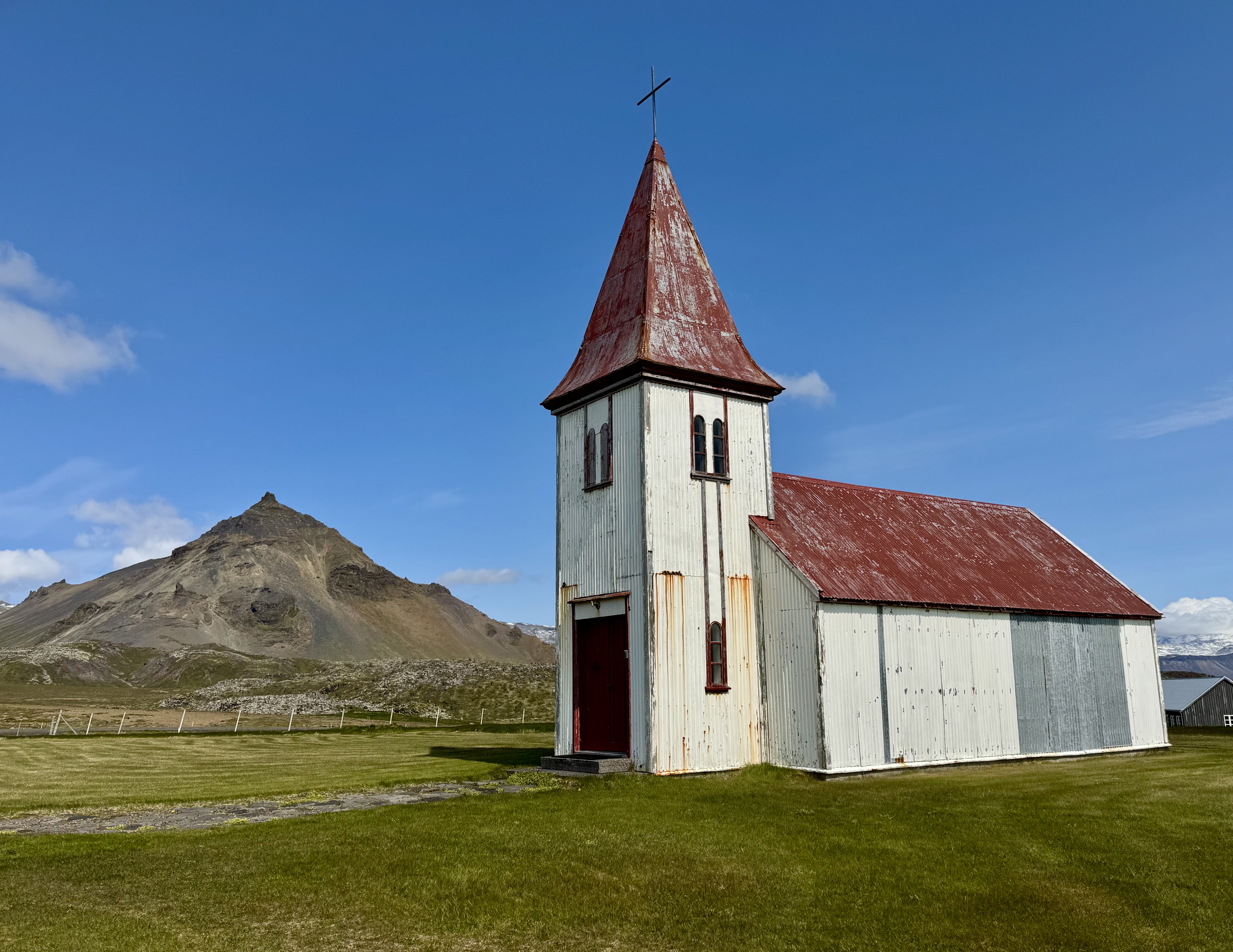
The Snæfellsnes Peninsula is rich in geological beauty with a glacier, volcanos, lava fields, coastal cliffs, rock formations, both white- and black-sand beaches, craters, and waterfalls. Farmhouses and barns, typically white with red roofs, nestle against the bases of the steep snow-topped mountains. Endless plains slant to the sea. Snæfellsnes is Iceland in a mussel shell.
This peninsula is where characters in Jules Verne’s Journey to the Center of the Earth discovered volcanic passageways they hoped would lead to the core of the earth. Verne never visited Iceland, but tourists can descend into Vatnshellir Cave, an eight-thousand-year-old lava tube.

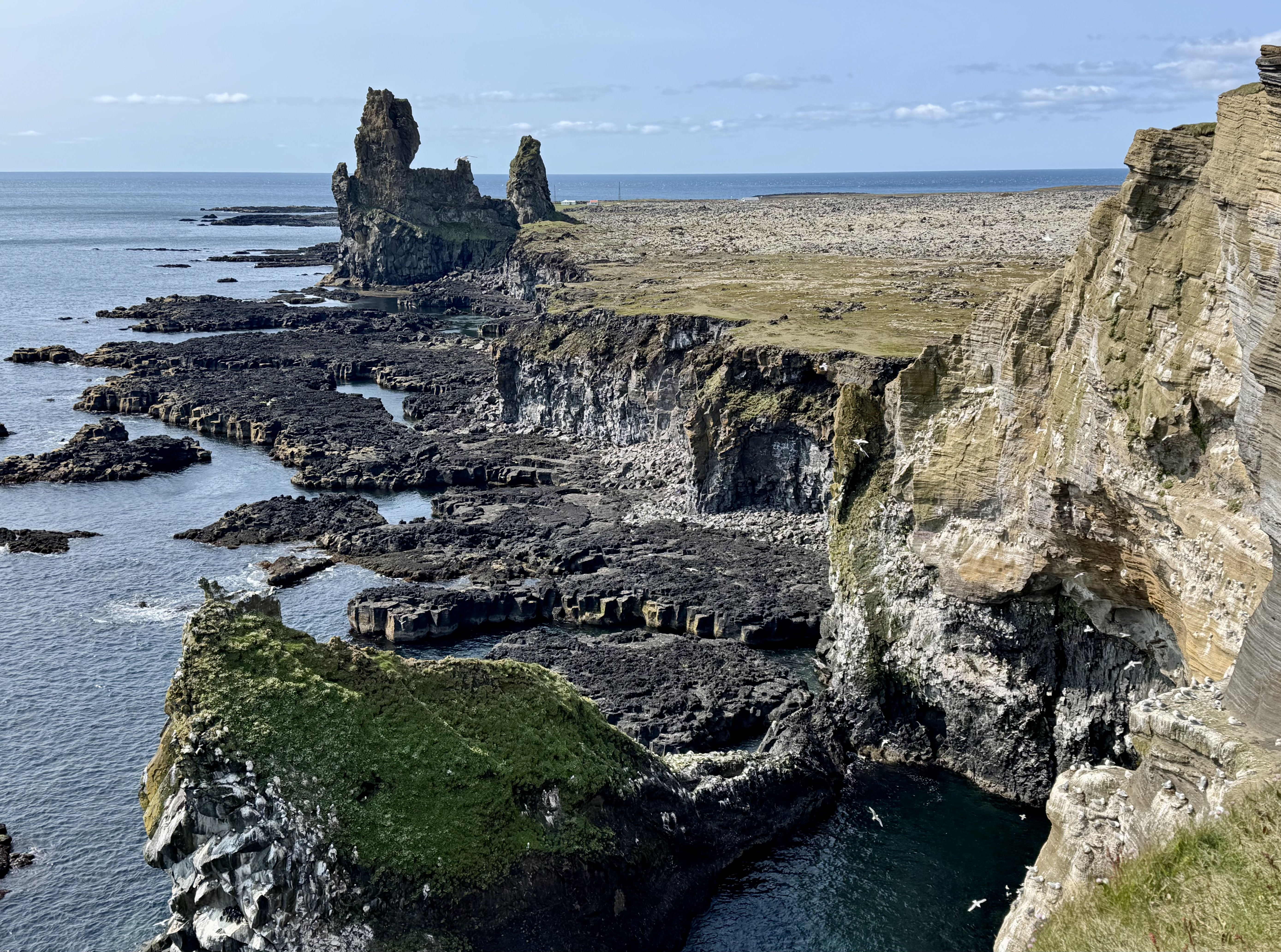
I hopped along the coast, stopping to visit several of the features. In Arnarstapi I hiked to grand Gatklettur, a stone arch carved perfectly by the sea. Nearby are hexagonal basalt-column cliffs, speckled with gulls. Further on, I stopped to see the Lóndrangar pinnacles, a couple of lava formations rising two hundred feet above the beach. They resemble giant sand castles, eroded by the waves.
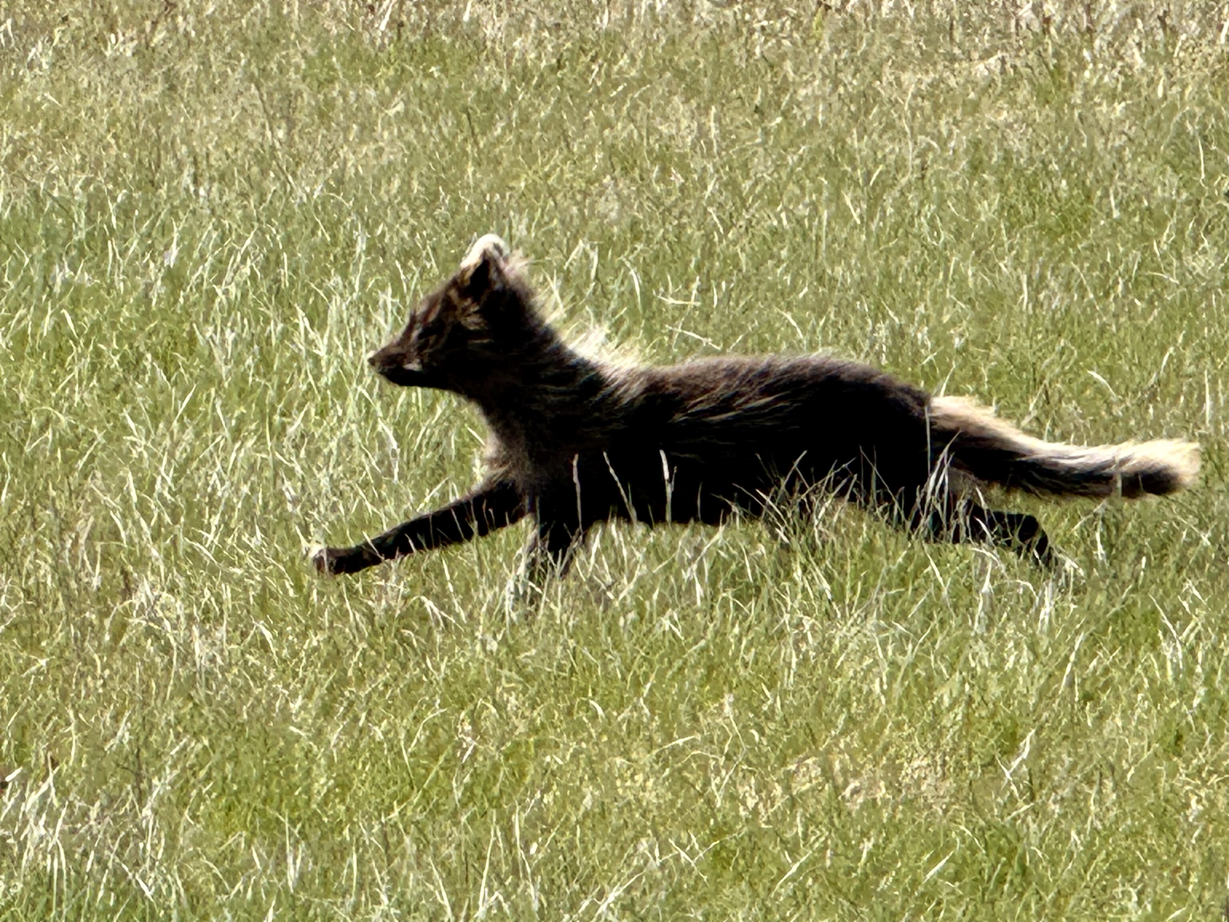
Near the pinnacles, a fuzzy Arctic fox scampered across my path. The Arctic fox is the only land mammal native to Iceland. All of the rest were brought intentionally (or unintentionally) by settlers. A protected species, Arctic foxes mate for life.
I attempted to visit the black-sand beach, Djúpalónssandar, but a ranger told me it was closed due to a landslide. Too dangerous, she said. On the northern coast near a series of fishing villages, I walked to Svödufoss, a thirty-five-foot waterfall.
One of the most dramatic sights in Iceland is Kirkjufell, which translates as churchyard or church mountain, perhaps due to its steeple-like peak. In Game of Thrones, it is known as Arrowhead Mountain.
Throughout the day, Snæfellsjökull hovered overhead, almost a mile above sea level, clouds drifting around its summit. The glacier caps a sleeping volcano, which last erupted in 200 CE.
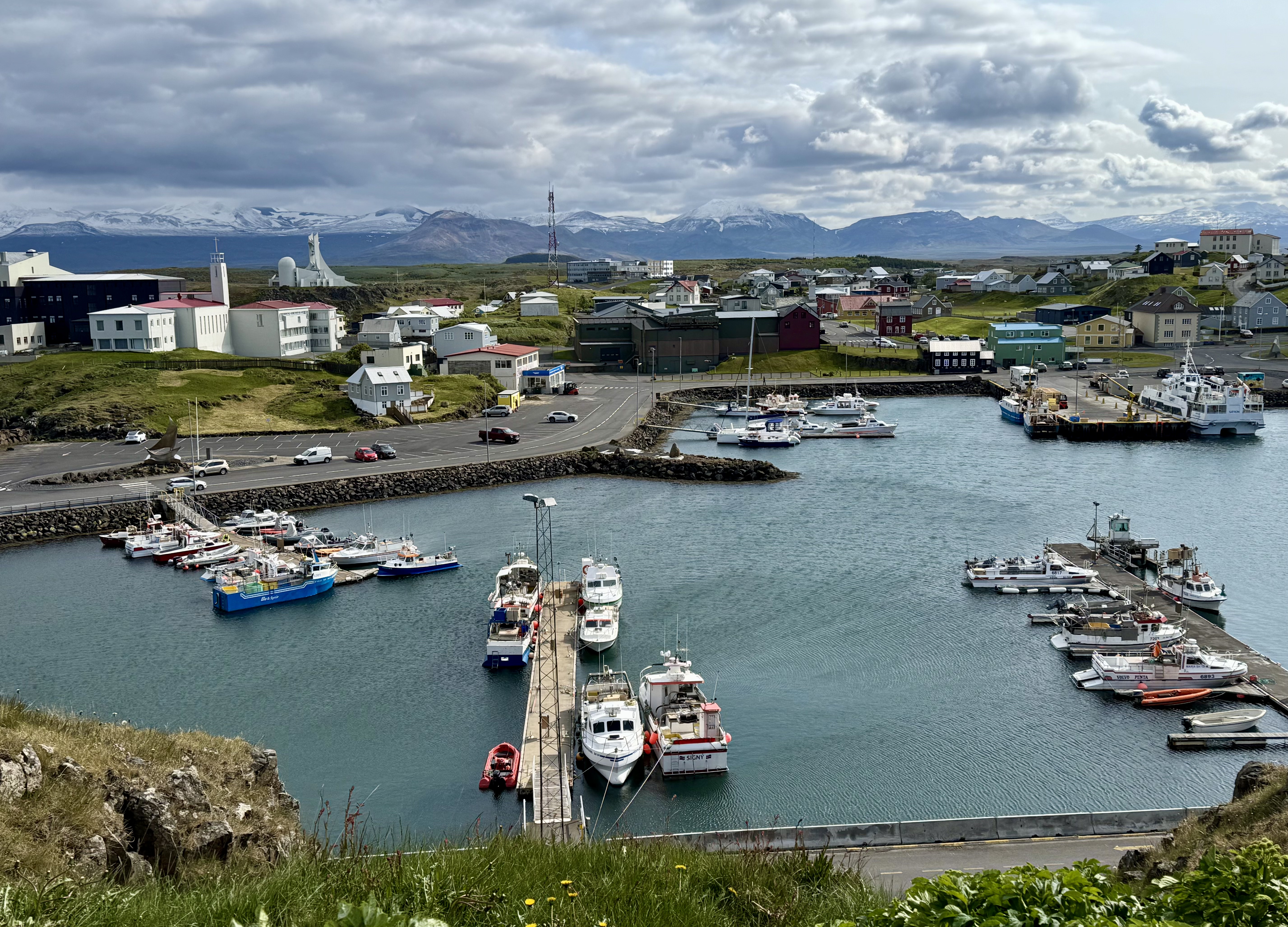
In Stykkishólmer, I checked into a one-hundred-and-sixty-year-old hotel overlooking the harbor. Strolled around town and climbed to the lighthouse on Súgandisey Island.
Every year in August, Stykkishólmer celebrates Danish Days, a festival honoring the town’s historic connection with Denmark.
Stykkishólmer has twelve hundred residents, many of whom are involved in fishing. That night at dinner, I had the best scallops I have ever had, freshly harvested from the bay across the street.
Late bloomers
Compared to much of the rest of the world, Iceland was settled late. The first known pioneers arrived in the 700s and 800s. They were Irish monks, Swedish and Norwegian Vikings, and Irish and Scottish slaves. They established farms and raised sheep.

In 930, the island’s tribal leaders founded the longest-running parliament in the world, the Alþingi, which assembled annually for nearly nine hundred years. Leifur Eiríksson, thought to be the first European to set foot in America, was born in Iceland around 970.
Eventually, infighting among the families brought Iceland under Norwegian rule in 1262. In 1397, Norway (and its colony, Iceland) became dependencies of Denmark.
In 1874 Denmark allowed Iceland its own constitution. In 1944 Icelanders voted overwhelmingly to separate from Denmark and establish their own republic.
Once, Norwegians and Icelanders spoke the same language—Old Norse.
Norway’s political relationships with Denmark and Sweden and its commercial involvement in the German-driven Hanseatic League influenced its language in a new direction. For a thousand years, isolated Iceland remained true to the mother tongue.
Today, Icelandic schoolchildren can read Icelandic sagas written in the 1100s, but Norwegians no longer understand Old Norse.
Turf’s up
In the morning when I checked out, there was an issue with my credit card. A few months ago, the card with which I reserved the room was compromised. The problem was quickly resolved with my replacement card. The clerk joked, “We weren’t worried. You wouldn’t get too far, too fast in Iceland.”

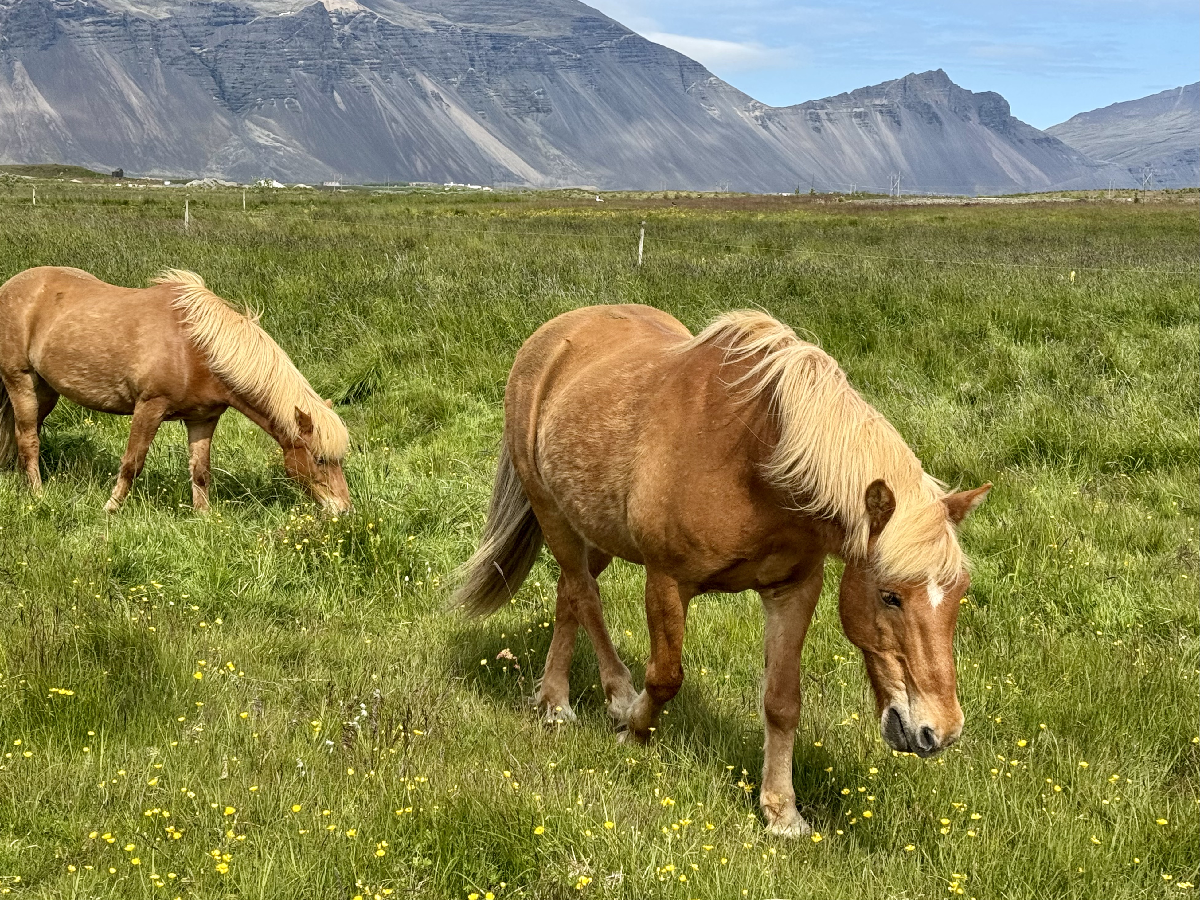
Much of the early driving today was on gravel roads, as I made my way from the Snæfellsnes Peninsula back to the Ring Road. I crossed multiple single-lane bridges. The fields were dotted with horses, spring foals, sheep, and spring lambs. The brighter and whiter the lambs, the more recently they were born.
Rained, sleeted, and snowed as I approached Skagafjörður, where I took dark refuge in the turf buildings of the Glaumbær Museum.
For a thousand years, turf was the primary building material in Iceland. With the scarcity of timber and the difficulty of working with basalt, turf was all Icelanders had on hand. To build a house, one-cubic-yard blocks of grass and soil were stacked and fitted together like Legos. Thick turf walls and ceilings provided insulation from the harsh winters.
The museum features a turf farmhouse of twelve rooms connected by a long central hallway. Some scholars believe that Iceland’s turf houses inspired the hobbit holes in J.R.R. Tolkien’s The Lord of the Rings trilogy.

Icelanders lived in turf houses from the 800s through the 1800s. Most turf houses in Iceland have been lost to the elements.
In 2002 the remains of a thousand-year-old longhouse were found in a nearby field, which perhaps once belonged to Snorri Þorfinnsson.
According to Icelandic sagas, Þorfinnsson’s parents lived for a while in what is now Newfoundland. Snorri was born there in the early 1000s. He is thought to be the first child of European descent to be born in the Americas (not counting Greenland).
Weather eye
I spent the night on another farm, this one with a commanding view of the wide Skagafjörður Valley. The farm raises horses and grows potatoes.

My plan for the day was to detour briefly from the Ring Road and drive the perimeter of the mountainous Tröllaskagi Peninsula. Most of the route is along the coast with views of several small islands. Eventually the road climbs into headlands that look north to the Arctic Circle. The mountain passes are steep with hairpin switchbacks and no guardrails.
Flurries were flying and giving me pause. Would the high mountain roads be icy?
The Icelandic Road and Coastal Administration provides around-the-clock information on the real-time condition of over eight thousand miles of roads, using its network of wireless weather stations and webcams.

Every morning before setting out, I turned to road.is for the latest updates on road-surface temperatures and wind speed. The site provides much more information, including the number of cars successfully passing various weather stations in the most recent fifteen minutes. Some mornings the traffic readings are zero, which doesn’t build confidence in the passability of those sections.
When I left, the tops of the mountains seemed spread with white icing. Clouds hung low, the wind blustered, and sleet pelted the windshield. But I was fortunate—the road was wet, but not slippery.

I passed through three tunnels, the longest over four miles, and one with only one lane. Oncoming drivers appeared to be on a collision course until one of us used the pull-over spaces.
I was relieved to descend from the mountains and enter the fishing village of Siglufjörður.
Fishing derby
Had I arrived in Siglufjörður in the early 1900s, I might have struggled to find a parking spot or hotel room. For several decades, Siglufjörður was a boomtown, all because of a small fish called the “silver of the sea.”
The village used to be a center of the herring industry. During peak years, herring accounted for nearly half of the nation’s exports. The fish helped ensure Iceland’s economic and political independence from Denmark.
While Siglufjörður was known as the Atlantic Klondike, thousands arrived seeking employment. The harbor was crowded with boats and the streets were packed with crowds. Investors built processing factories.
When the fishing fleet arrived, brimming with the day’s catch, the so-called herring girls went to work. Hundreds of young women from around Iceland found employment on the docks of Siglufjörður, where they beheaded, gutted, and packed fish into barrels of salt. They worked long hours and were paid by the barrel. Dormitory-style housing was provided by their employers.
Throughout history, vitamin-rich, affordable herring has been an important staple. Tinned herring was a core component of diets during both world wars.

Siglufjörður’s boom continued until the herring disappeared. The village’s economy slumped and its population declined.
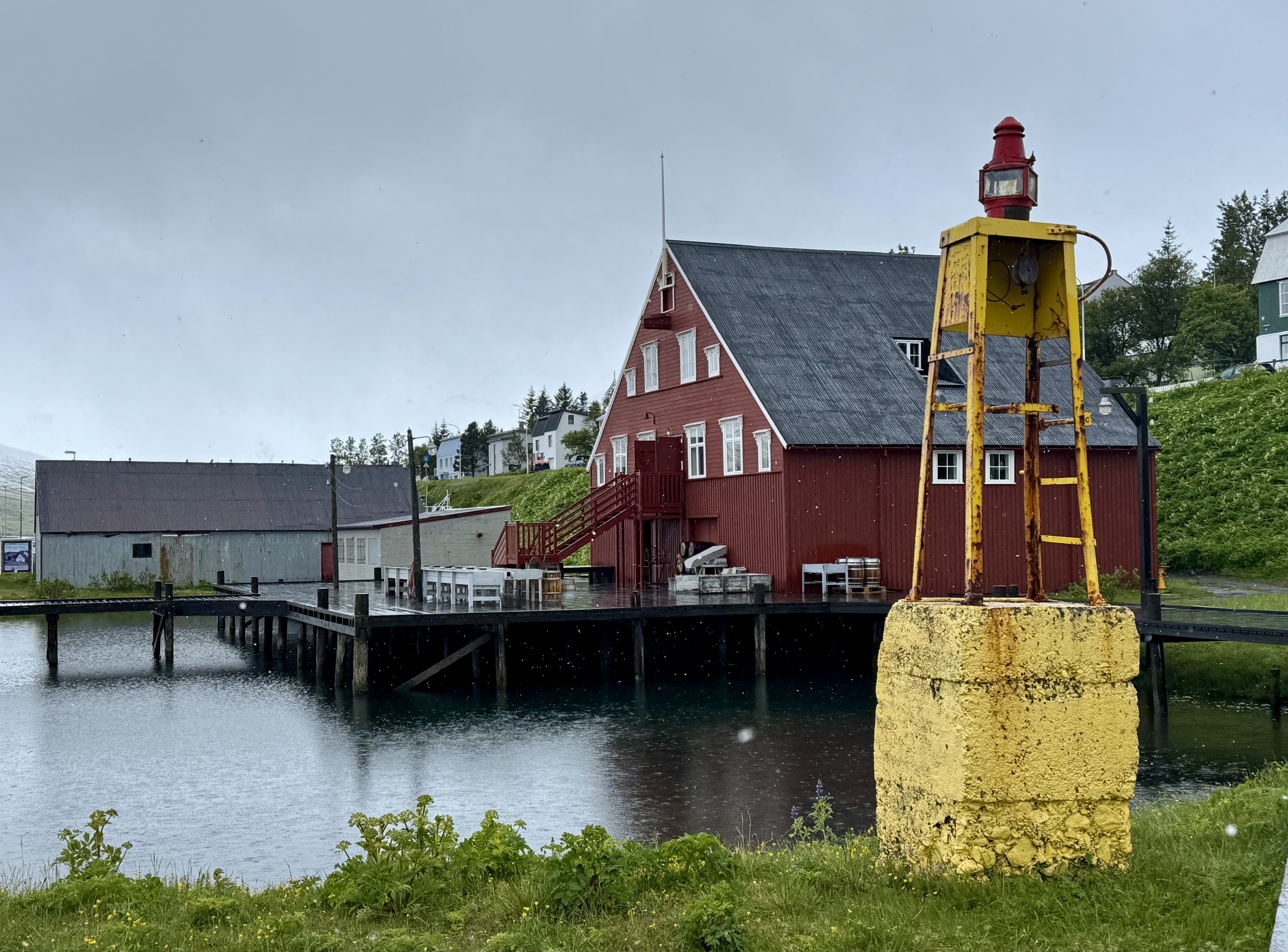
The Herring Era Museum relates the history of the industry and the role the little fish played in helping Iceland gain its independence.
One building showcases equipment used for producing fishmeal, an ingredient in livestock feed and fertilizer. Another contains eleven fishing boats arranged as if jammed between docks. The main museum building was once a salting station, one of twenty-three in town.
Upstairs, are the original living quarters of fifty herring girls, with rows of bunkbeds and a shared kitchen. Vintage clothing hangs from hooks and personal items are scattered around as if the girls just left for work.

Hot stuff
Volcanoes, geysers, hot springs, fumaroles, and mud pots are manifestations of two geological processes that have been at play in Iceland for millions of years.
One of them is plate tectonics.
The earth’s outer layer, averaging about twenty-six miles thick, is broken into seven major plates (with some smaller puzzle pieces left over). Iceland straddles a crack between two of the larger plates, North America and Eurasia. As these plates bump and grind against each other, the movement creates earthquakes, volcanic activity, and new mountain ranges.

The fault line between the plates is visible in a few different spots around the island.
Number two is mantle convection, the movement of heat from the center of the earth to the surface.
Iceland sits on a hot spot—a location where the earth’s outer layer is thin and a mass of molten rock is near the surface. Heat escapes through the crust as lava, hot water, or hot gas. Iceland is one of the most active volcanic regions in the world.
Hundreds of years ago, the Vikings tapped Iceland’s geothermal energy to bathe, wash clothes, and cook. Modern Icelanders are harnessing the heat to generate electricity. Most homes in Iceland, as well as the hot tubs, are heated with geothermal energy.
Boiling point
After Siglufjörður, I traveled to a nature preserve where volcanic manifestations are not only evident, but active.
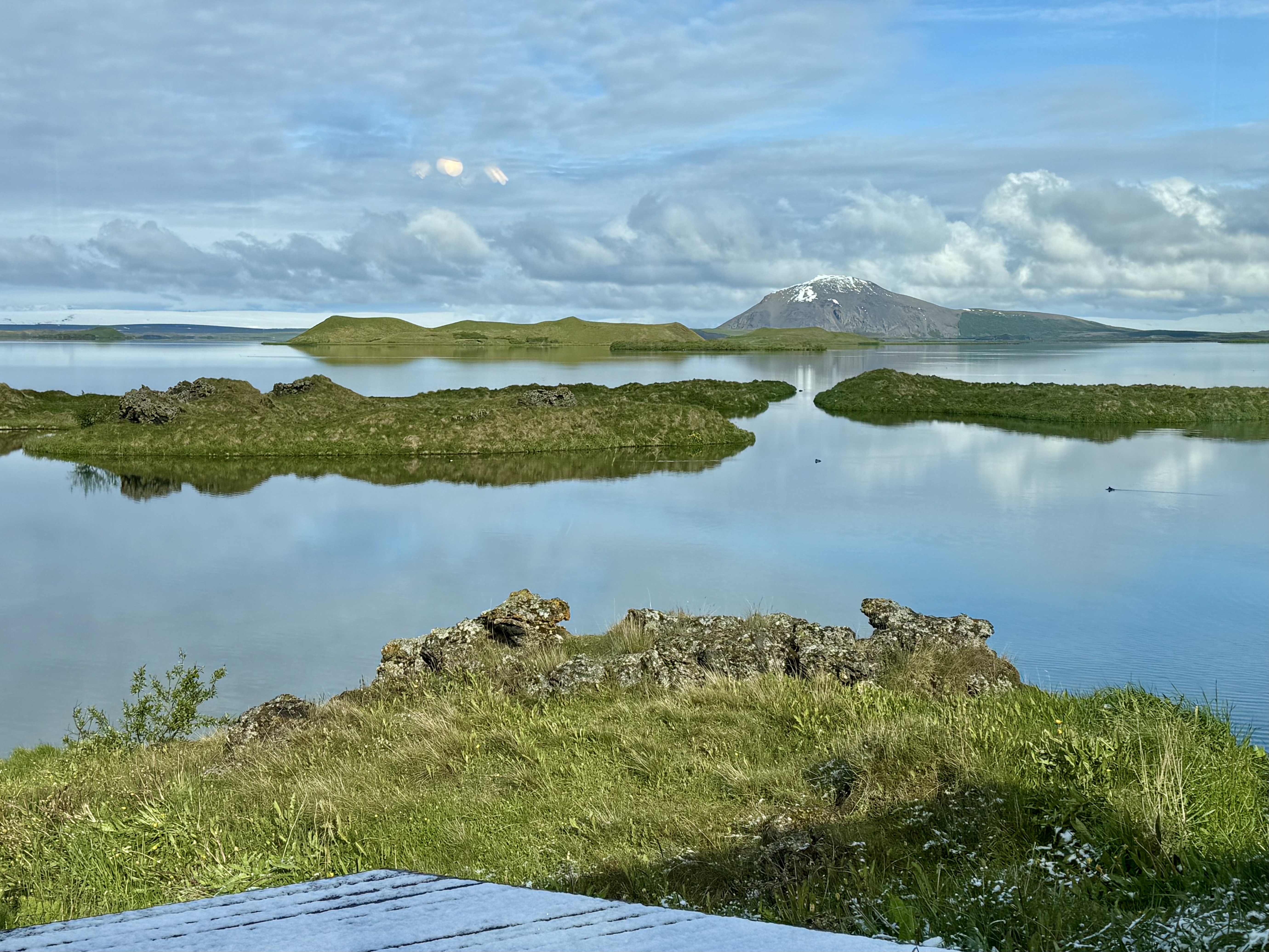
The shallow fourteen-square-mile lake, Mývatn, was created by a large eruption twenty-three hundred years ago. Mývatn translates as Midge Lake, a name honoring the tiny gnats that swarm there. None bothered me, but perhaps it was too windy.
The area is a survey course of the many forms through which heat escapes the earth’s core. I spent a day exploring them.

Just east of the lake is Námafjall, a geologist’s dreamscape. Fumaroles spew thick, sulfuric clouds of steam. Pools of blue mud bubble and burp ferociously. Rivulets of piping hot water stream across the surface. Mineral deposits paint the terrain blue, orange, yellow, and red. The plain is otherworldly.
Signs in the geothermal wonderland warn that temperatures can exceed two-hundred degrees Fahrenheit. Boardwalks have been erected along an edge to help prevent exposure. Still, some tourists venture across steamy ground to get a look at boiling, spattering mud pots up close.
On Mývatn’s southern shore, the large depressions in the ground look like craters, but are known instead as pseudocraters.
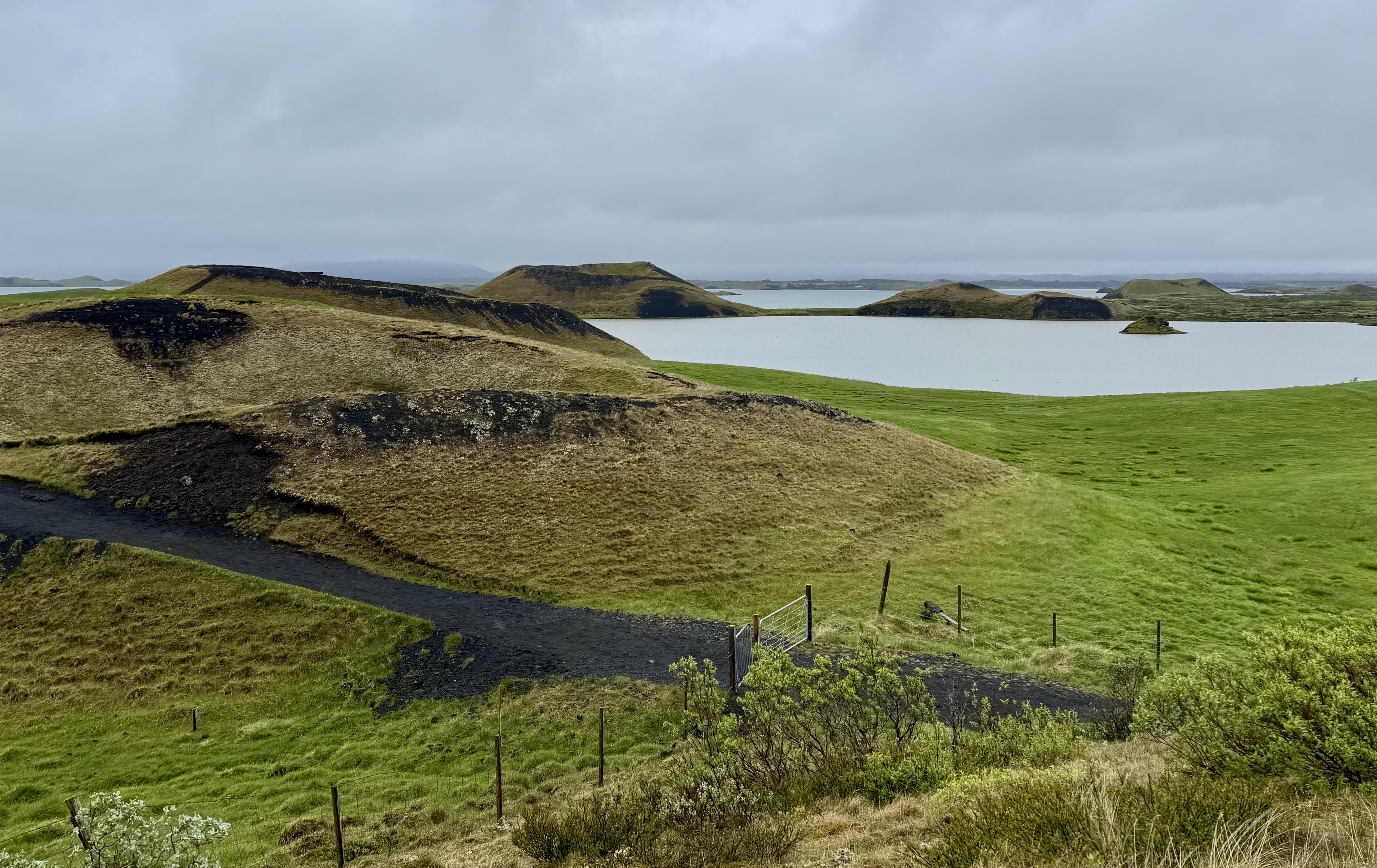
Why pseudo? Real volcanic craters are caused by an eruption of hot gas and lava through a hole in the ground. The fake variety are formed when hot lava flows on top of lake water, creating bubbles of hot steam below the surface. When the bubbles rise to the surface of the lava, they burst, leaving crater-like concavities.
I walked through Mývatn’s field of fake craters, climbing up staircases to peer down into the grassy circular indentations. The lava bubbles must have been as big as sports domes.
However, some lava did find its way through vents at the bottom of the lake. Upon contact with the water, the lava solidified into gnarly formations beneath the surface. Eventually the lake receded, leaving scraggy pillars of lava behind.

On the east side of the lake is a cluster of lava pillars, a forest of jagged columns and spires.
The park is called Dimmuborgir, the Black Castles. A maze of hiking trails wends around and through the craggy formations.
The day wouldn’t have been complete without a soak in the community’s hot pool. I relaxed for a while in a lagoon of geothermal water, drawn from below the earth’s surface.
Around the lake are farms, many in the same family for generations, many providing lodging and dining. I ate dinner in a barn, while watching cows being milked. The restaurant is called the Cowshed Café. Real farm to table. My grandparents, dairy farmers, would have found the concept astounding and perhaps ridiculous.
Access pass
A sign in the breakfast room said access to the giant waterfall, Dettifoss, was closed due to a recent landslide. I headed instead to Stuðagil Canyon.
The landscape between Mývatn and the turnoff to the canyon is desolate high country, much of it mile after mile of volcanic cinders surrounded by flat snow-topped mountains and few signs of humanity.
The gravel side road to the canyon was unpaved and potholed. I slowed several times as ewes and lambs sauntered in front of the car. The park entrance is on a bluff above the canyon. From there, I walked down several flights on a steep metal stairway fastened to the side of the rock wall.

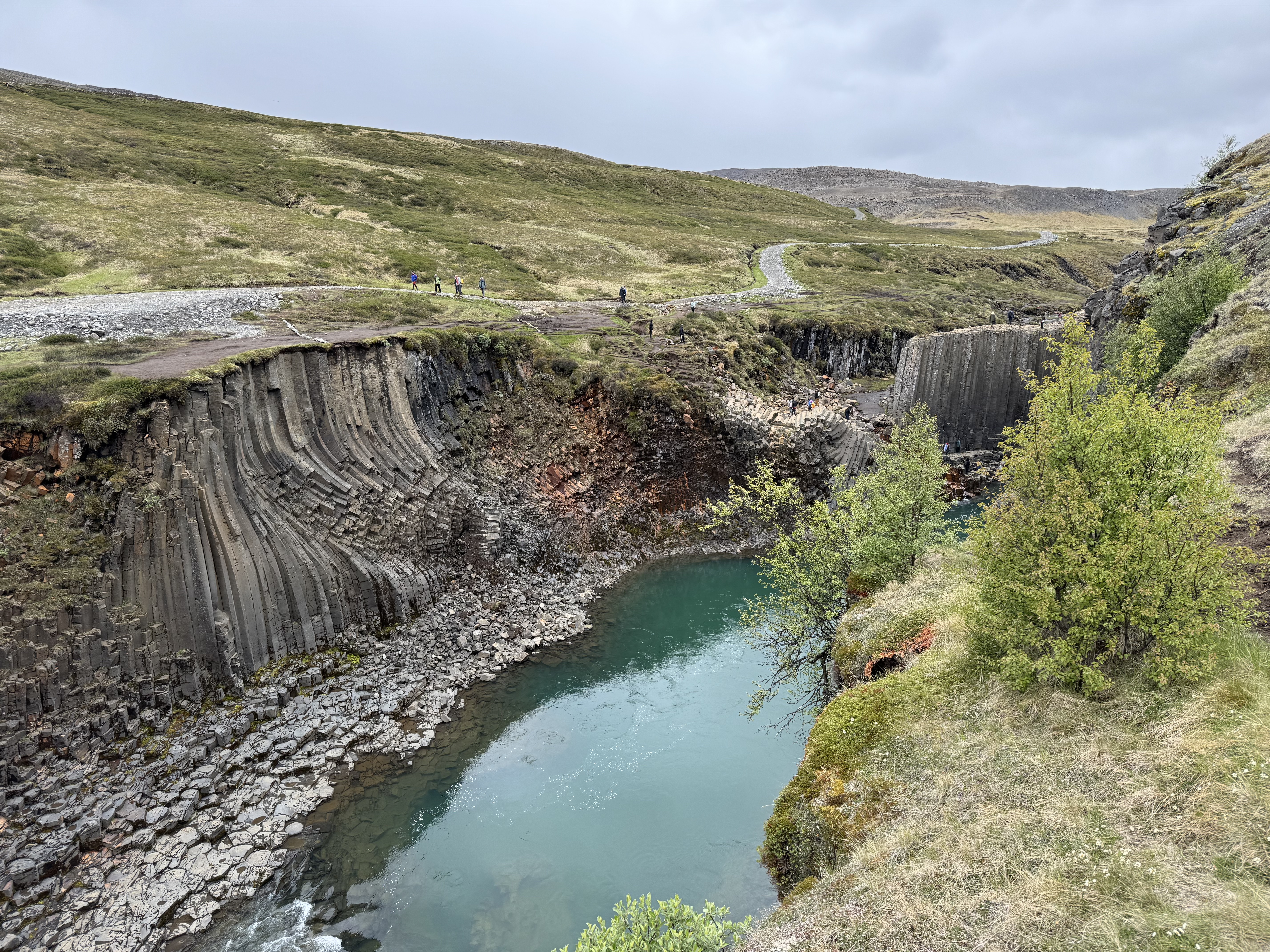
The one-hundred-foot cliffs of Stuðlagil Canyon are jumbled with massive clumps of hexagonal basalt columns, some standing upright, some stacked like lumber, some bent sideways like licorice sticks. A few daredevils clambered on the slippery hexagons above the turquoise river.
Back on Route 1, I continued to Egilsstaðir. It was time to tackle the scary Fjarðarheiði Pass, often snow-covered and foggy. I steadied myself and headed up, climbing switchback after switchback, not a guardrail in sight. I didn’t bother looking down at what is considered a stunning view. My lane was too narrow to take my eyes from the road.

Finally at the top I entered a dark, eerie, misty land of frozen lakes. Ice in the water was broken into slabs. On the far side of the mountain I crept down the switchbacks through heavy fog and into the coastal town of Seyðisfjörður.
Seyðisfjörður sits at the head of a ten-mile-long fjord leading to the sea. Although the village is tiny (population seven hundred), it is a popular cruise-ship stop. My hotel was a former post office with a view of the seals in the harbor. While I was there, a small cruiser from Bergen, Norway, was in port for a few hours.
During the night I got up to go to the bathroom. (I’m old.) Bright sunlight was streaming through the windows. On the north cost of Iceland near the solstice, the sun sets around 1 a.m. and rises a half-hour later. In between the sky will dim but never fully darken—twilight time.
Blackout curtains were provided in the places where I stayed. Other countries that experience midnight sunshine are Greenland, Norway, Sweden, Finland, Russia, Canada, and the U.S. (Alaska).
Surf and turf
At breakfast, the buffet included a bottle of Icelandic cod-liver oil and shot glasses. I headed back through the pass to Egilsstaðir, this time in full sun, and headed south along the Eastfjörðs.
Today was the longest drive of the trip—four hours and no big sights. Still, the scenery was magnificent all day with craggy mountains, long green valleys, fjords, broad bays, waterfalls, tunnels, farms, beaches, islands, lighthouses, and a sea stack. The roadsides were blanketed with blue Nootka lupines. Frequently I slowed for sheep on the road.

Around a bend I spotted a herd of fifteen reindeer grazing on a hillside. Reindeer were imported to Iceland from Norway in the 1700s. Only those in eastern Iceland survived. The population today is around six or seven thousand.
Reindeer are ruminants, eating mostly grass, lichen, and shrubbery. Their coats are dense with hollow hairs, which provide insulation. In the winter their wide hooves work like snowshoes.
In the afternoon I arrived in the fishing village of Höfn and checked into the Milk Factory, a former dairy repurposed as a small hotel. My room had a view of the Hoffellsjökull tongue of the Vatnajökull glacier. Across the road from the hotel, a herd of Icelandic horses posed for photos.
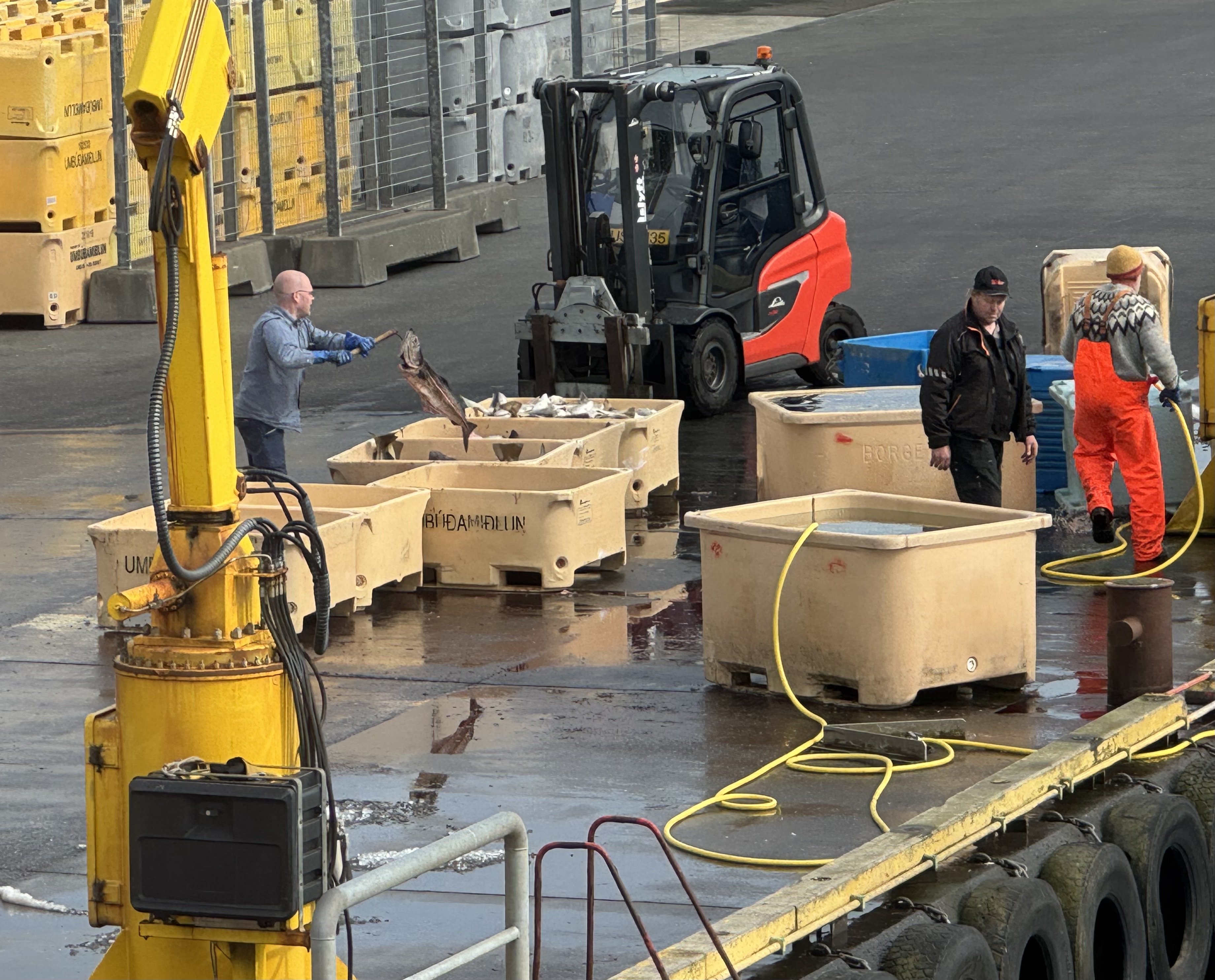
In town I found a restaurant overlooking the docks where workers were unloading a catch of cod from a fishing boat. A crane hoisted bins of fish onto the dock and a front-end loader buried each load in ice.
While watching, I enjoyed the local speciality, langoustine served on a roll with avocado, tomato, and lettuce. Langoustines are small lobsters.
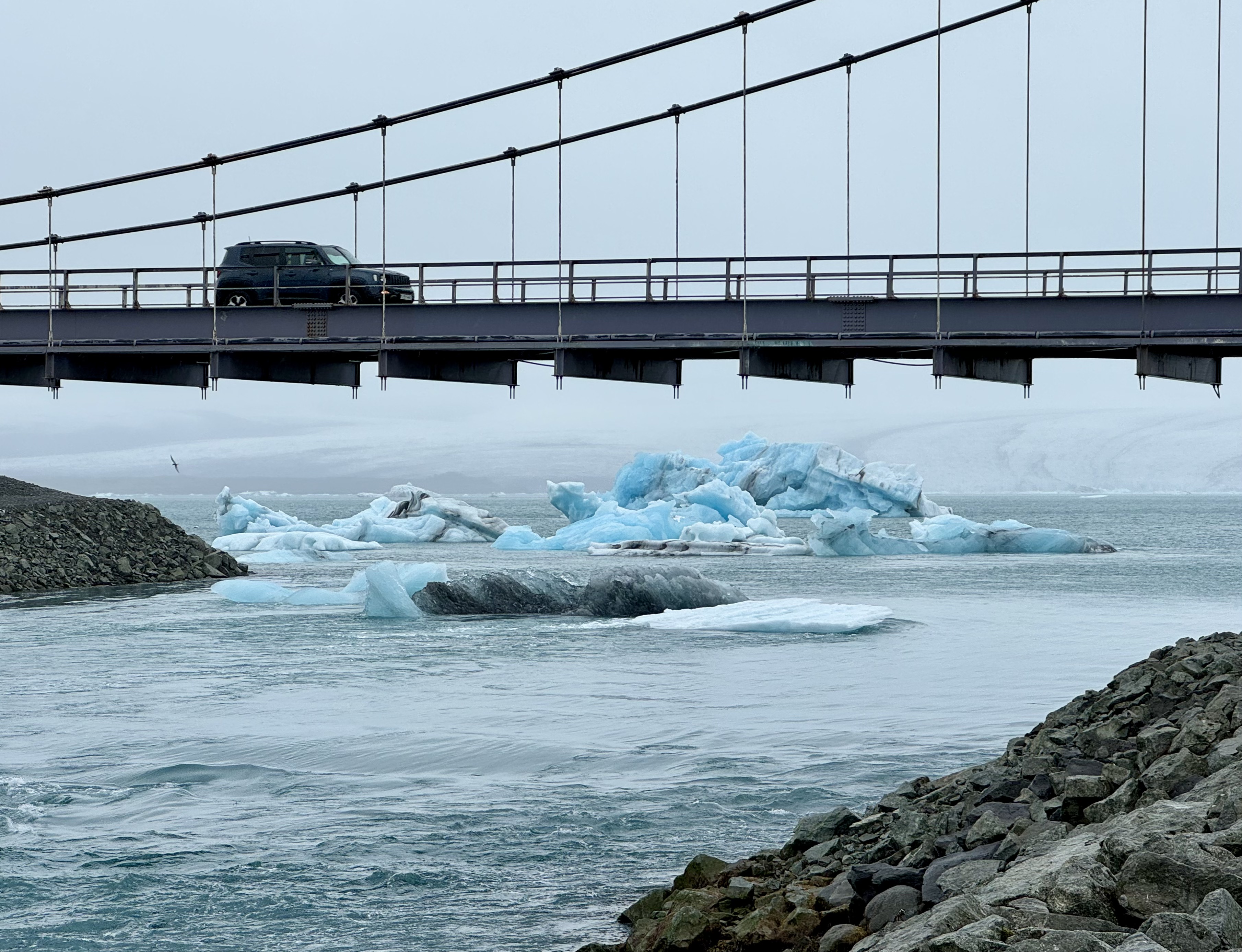
Ice sculptures
I wasn’t expecting to see icebergs bobbing along the side of the road.
As the glacier called Breiðamerkurjökull recedes, its meltwater collects in a glacial lake, called the Jökulsárlón Glacier Lagoon.
The lagoon is jammed with icebergs that have calved from the glacier. The ice chunks drift through the lagoon and gather at its exit. As I approached, I was astounded to see blocks of blue ice protruding above the level of the road.
The icebergs bob around, melt into smaller chunks, and eventually float out to sea. Only ten per cent of icebergs are visible above the surface.
The parking lot for viewing the phenomena was packed. Some swaddled tourists headed into the lagoon in motorized rafts and amphibious boats for a closer view. Others hiked along the shore.
The lagoon has been a setting for several Hollywood movies, such as A View to a Kill, Die Another Day, and Batman Begins.
Across the road is Diamond Beach, where mini-bergs wash onto the black sand and reflect the sunlight. The shiny, smooth chunks of ice, tumbled by waves, are all shapes and sizes, some as big as small automobiles. People pose with them, sometimes in the freezing waves.
Down the road I visited another lagoon, Fjallsárlón, smaller and much less crowded. From the parking area, I hiked up the glacial moraine to the lake and found it filled with blue ice. For a few moments, I was the only one there. Complete silence. Just the glacier, the icebergs, and me.

Rounding the bend
I spent the night in Kirkjubaejarklaustur. Just wanted to use that name once. Then, continued to Vik, a more user-friendly moniker.
Vik, with a population of eight hundred, is the southernmost village in Iceland. I was now rounding the bend and in the home stretch toward Reykjavik.
The south coast is rich in geological features. The Reynisfjara beach is buried in smooth tiny pebbles resembling black pearls. Nearby are hexagonal basalt columns, caves, and the Reynisdrangar sea stacks. A paraglider soared overhead.

More sea stacks, including a natural stone arch, were below the Dyrhólaey Promontory. After a steep, winding drive to the top, I walked to the lighthouse and enjoyed the view up and down the coast.
I continued west, stopping to visit two massive waterfalls—Skógafoss and Seljalandsfoss, both two-hundred-feet tall and both fed by glaciers, Mýrdalsjökull and Eyjafjallajökull. The latter is the volcano that erupted in 2010 and halted air traffic in Europe for nearly a week.
After a night on a farm in the middle of a horse pasture, I headed toward the touristy Golden Circle. On the way, a herd of about twenty Icelandic horses, mares with their foals, trotted single-file along a fence next to the road. Apparently the moms got together and agreed, “Wake up, kids! It’s time for some exercise!”

Gulfoss is more developed than when I visited in 2012, but the falls are still an astounding force of nature. The Hvítá River plunges twice, thirty-five feet and then seventy feet, into a perpendicular crevice that is one-hundred-feet deep. A double falls.
In the middle of a huge complex of greenhouses is a restaurant featuring a tomato-based menu. Diners sit between rows of tomato plants. Pots of basil are on every table. The bar mixes Bloody Marys. For lunch, I had all-you-can-eat tomato soup. A family-run business, the Friðheimar Tomato Farm produces half of the tomatoes in Iceland.
I continued to the Geysir geothermal field filled with fumaroles, mud pots and, of course, geysers. Strokkur is the star geyser. It erupts every five or ten minutes. I was fortunate to catch several of its impressive spurts.

The English word geyser (a periodically spouting hot spring) derives from the Icelandic geyser called Geysir. These days, Geysir is rather forlorn, sidelined by Strokkur’s performances. A sign said, “This geyser is dormant. Eruptions are rare.” I know the feeling.
Full circle
At the breakfast buffet I sampled warm volcanic bread. The dough is made with dark rye flour, whole-wheat flour, buttermilk, golden syrup, baking powder, baking soda, and salt. Once kneaded, the dough is sealed in a metal container and buried in a geothermal area to bake for twenty-four hours. It’s very dense.

I visited Þingvellir, the site of the Alþingi, Iceland’s annual parliament session from 930 to 1798. Þingvellir in Old Norse means assembly field.
The Þingvellir area was chosen for its accessibility to the tribes of the island. The longest journey for a tribal leader to the gathering was seventeen days. The first parliament in the summer of 930 laid the foundation for Iceland’s cultural identity.
During the assemblies, temporary turf huts dotted the landscape. Traces of shelters have been found on the site. Business was conducted, marriages arranged, legislation passed, disputes settled, and criminals (plus a few suspected witches) executed. Fun for the while family.
The early Icelanders had no idea that their assembly field straddled the boundary between two tectonic plates—North America and Eurasia.

In Reykjavik I left the Ring Road. The circular journey was complete. Including the side trips, I drove 1,414 miles.
I explored the capital city, revisiting some favorite sights from 2012. Mostly, however, I reflected on the adventure.
The landscape of Iceland is pristine and I was fortunate to experience it at my own pace. Spring arrived during my visit. Windy mornings in the thirties with the threat of icy roads gave way to afternoons in the sixties with sunshine. And midnights with sunshine.
The geography of the Ring Road makes a multitude of natural wonders accessible for firsthand experiences. I visited eight waterfalls, five glaciers, two geothermal fields, two lagoons filled with ice bergs, a geyser, lava formations, sea stacks, a couple of beaches, a tectonic gorge, and a basalt canyon. I visited museums, turf houses, and lighthouses. I was lucky enough to spot an Arctic fox and a herd of reindeer.

Beyond the attractions, I enjoyed the commonplace. The red and white farm buildings snuggled against the mountains. The spring lambs trotting behind their moms as they crossed the road. The blond manes of the Icelandic horses swirling in the wind. The snow-dusted mountain tops. The whitewater brooks. The moss-covered lava fields. The bluish-purple Nootka lupine on the roadsides. The welcoming harbors and fresh seafood.
As road trips go, the Ring Road is iconic.

One of your best. The dinners sounded amazing.
What wonderful scenery and experiences rarely experienced by others, I’m sure. Thanks for sharing.
What a great read! That intro was, as the kids say, fire.
fabulous trip and terrific writing Kirk.